
Most Himalayan expeditions ask you to choose culture or summit, scenery or altitude, valley or peak. The Markha Valley combined with a Kang Yatse 2 expedition refuses to make you choose.
Over 11 days, this route delivers both: a journey through one of Ladakh’s most storied valleys past ancient monasteries, barley fields, and the warm hospitality of Buddhist communities and then, at the top of that same valley, a genuine 6,250-metre summit that puts you in a world of glaciers, crampons, and sunrise light on the Karakoram.
It is, simply, the most complete adventure available in India right now.
Since Stok Kangri’s closure by the Indian Mountaineering Federation, Kang Yatse II has become the definitive objective for trekkers seeking their first 6,000-metre summit in Ladakh. But what separates it from every other 6,000 m peak in India is the approach: you don’t drive to a base camp. You walk there through 80 kilometres of some of the most extraordinary trekking terrain on earth. By the time you stand below the mountain, you have already lived an expedition worth remembering.
This guide walks you through every stage, from the dusty lanes of Leh to the summit ridge at sunrise.
Leh, Where Every Ladakh Story Begins
Your expedition opens in Leh (3,524 m), the ancient capital of the Ladakhi kingdom. Two full days here are non-negotiable not just for acclimatisation, but for orientation. The altitude hits differently than people expect. Even fit trekkers feel the breathlessness of 11,500 feet. Slow walks, hydration, and good sleep are your only tools.
Use the time well. Shanti Stupa at sunrise delivers one of the finest views of the Indus Valley. The Leh Palace, a nine-storey mud-brick structure that once housed the royal family — looks out over the town’s rooftop maze. In the bazaar below, you’ll find dried apricots, thukpa soup, and the quiet rhythm of a Buddhist city that has been receiving travellers for centuries.
Your guide will also complete paperwork and Inner Line Permit formalities here, clearing the way for the valley ahead.
Chilling to Skiu, The Valley Opens
The drive from Leh to Chilling traces the Indus River, passing Sangam Point where the grey Zanskar River pours into the blue Indus — two rivers, two colours, meeting in slow collision. This is one of those sights that makes you stop the vehicle and stand at the bank.
At Chilling, you cross the Zanskar River and the Markha Valley truly begins.
The first day of walking — Chilling to Skiu (3,400 m) — is a gentle introduction to what the valley demands. The trail runs along the riverbank through narrow gorges, over wooden bridges, past mani walls painted with Tibetan prayers. Skiu itself is tiny: a handful of stone houses, a small white stupa, the ruins of a palace that once held considerably more authority than its crumbling walls suggest. Camp here under a sky that has almost no light pollution. The Milky Way will be the last thing you see before sleep.
Skiu to Markha, Into the Heart of the Valley
The section from Skiu to Sara to Markha (3,700 m) is where the Markha Valley reveals its character. The Markha River is your constant companion — cold, clear, fed by glaciers, crossed and re-crossed on wooden bridges and, in places, through knee-deep fords that you simply walk through, boots in hand.
Sara village stops you completely. Barley fields the colour of jade spread across the valley floor, surrounding stone and mud houses that look grown rather than built. A small café here serves butter tea to trekkers, and the owner’s children will almost certainly inspect your camera with professional curiosity.
Markha village is the valley’s largest settlement — about 20 households, an old monastery on the hillside, fort ruins above it, and a row of prayer flags that snap in the afternoon wind. This is the village that gives the valley its name, and it has been here long enough to appear in medieval Tibetan historical texts. Spend time walking through it. Speak to the residents if you can. The culture you are passing through is not a backdrop — it is the point.
Markha to Thachungtse, The World Gets Higher
The day from Markha to Thachungtse (4,100 m) marks the transition from valley trekking to expedition mindset.
The trail passes through Umlung, a small settlement where you get your first clear, unobstructed view of the Kang Yatse massif. It stops you. The peak is throne-shaped, broad at the shoulder, glaciated on its upper faces, and improbably large against the sky. For most trekkers this is the moment the summit changes from an idea into an objective.
Beyond Umlung, you pass the Tacha Monastery — perched against a cliff face in a position that seems structurally impossible, decorated with faded murals that predate most European monasteries by centuries. Hankar village, the highest permanently inhabited settlement in the valley at roughly 4,000 m, lies just below Thachungtse. Blue sheep (bharal) are regularly spotted on the slopes above it, sometimes in herds of thirty or forty, utterly unconcerned by humans.
Thachungtse campsite sits beside a stream in a wide meadow, with Kang Yatse now dominating the southern horizon. Sleep here at 4,100 m is your first real acclimatisation test.
Thachungtse to Nimaling, The Expedition’s Soul
Nimaling (4,700–4,900 m) is where the Markha Valley and the Kang Yatse expedition become one. This high-altitude pasture a wide, grassy bowl ringed by peaks, is where Changpa nomadic herders bring their yaks and pashmina goats through summer, and where the base rhythm of the mountain world becomes audible.
The campsite at Nimaling is widely regarded as one of the finest in all of Ladakh. On a clear evening, Kang Yatse I and II rise directly to the south, their glaciers catching the last light. To the east, the Indus Valley stretches towards Tibet. At night, the lack of any human light source makes the stars extraordinary; photographers routinely describe this as the most satisfying night sky they have ever shot.
This is not just a beautiful campsite. It is also the operational heart of the expedition. The altitude here provides the acclimatisation required for a summit push above 6,000 m. Your guide will take you on a training walk, introduce you to crampons and harness on flat terrain, and brief you on the following days.
Hemis National Park, the largest national park in South Asia, encompasses this entire section of the route. Snow leopards live here. You are unlikely to see one, but you are walking through their territory, and that awareness adds a particular quality to the silence.
Nimaling to Base Camp, The Mountain Takes Over
The trail from Nimaling to Base Camp (5,200 m) crosses a landscape the valley sections could not have prepared you for. The greenery ends. The path climbs through loose moraine and scree, the rubble left behind by retreating glaciers, towards a broad plateau directly below the mountain’s glaciated south face.
Base Camp at 5,200 m is a collection of tents on rock, with the peak filling the sky above and nothing between you and the summit but altitude and will.
The day after arrival is your acclimatisation day. You climb to approximately 5,500 m, practise walking in crampons on real snow, learn basic rope techniques, and return to base camp for an early dinner. Everything from this point forward is about the summit.
Summit Day, Before Dawn on a 6,000-Metre Kang Yatse Peak
You leave base camp between 11 pm and midnight.
Summit day on Kang Yatse 2 begins in complete darkness, under headlamps, on a 6,000-metre Himalayan peak, with the temperature around minus 10°C and the only sound your own breathing and the crunch of boot on moraine.
The early sections climb loose moraine and scree. As you gain altitude and reach the snowline, crampons go on, ropes come out, and the pace slows to match the thinning air. The route follows the shoulder of the mountain, angling upward through 30–40° snow slopes. At some points, crevasses lurk below the snow surface, and your guide will rope the team together for safety.
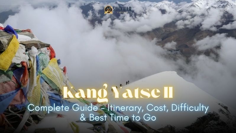
The summit itself — a narrow snow crest at 6,250 m — arrives around sunrise if you have moved well through the night.
The view from the top is extraordinary. To the west, the Zanskar Range sweeps away in a cathedral of white and grey peaks. To the north, on the clearest days, the Karakoram appears on the horizon — and within it, if the sky is right, K2. To the east, the Tibetan Plateau stretches endlessly beyond the valleys you crossed during the expedition.
The descent returns to base camp before the afternoon sun softens the snow. Your body will need most of the next day to recover.
The Descent, Kongmaru La and Out
The return route crosses the Kongmaru La pass (5,260 m) — a high Himalayan pass decorated with prayer flags, from which you can see both Kang Yatse summits behind you and the Indus Valley far ahead.
The descent from Kongmaru La is steep and enters a narrow canyon of vividly coloured rock — layers of ochre, red, and purple that look geological in their precision. The canyon opens into Chakdo village, where vehicles wait to drive you back to Leh.
The contrast between summit day and arriving back in a Ladakhi village with hot tea is something that takes weeks to fully process.
Who Is This Kang Yatse Expedition For?
The Markha Valley + Kang Yatse 2 expedition is not a beginner trek. It is designed for trekkers who have completed multiple Himalayan trails at altitude and are ready to take the next step into mountaineering.
You are ready if you:
- Have trekked to 4,500 m or higher and handled altitude well
- Can walk 6–8 hours per day for multiple consecutive days
- Are physically active and comfortable with endurance activity
- Are mentally prepared for a cold and demanding summit push
You do not need:
- Prior technical climbing experience
- Previous summit experience
- Special mountaineering certification
The expedition is classified Alpine PD (Peu Difficile), making it the ideal first mountaineering expedition for serious trekkers.
Best Season: When to Book Your Kang Yatse II 2026 Expedition
| Month | Conditions | Verdict |
| June | Trail opens, cold nights, fewer trekkers | Good — early season |
| July | Warm days, stable weather, peak wildflowers | Excellent |
| August | Best summit conditions, warmest nights | Best month |
| September | Post-monsoon clarity, cool temperatures, autumn colours | Excellent |
| October | Risk of early snowfall on summit | Advanced trekkers only |
Shikhar Travels runs fixed departures from late June through early September with small group sizes for better acclimatisation and summit success.
Essential Gear Checklist for Kang Yatse 2
Provided by Shikhar Travels
- Common climbing equipment
- Complete kitchen and camping setup
- First aid kit with oxygen cylinder
- Ponies for luggage transport
Personal Gear Required
- Mountaineering boots
- Crampons
- Ice axe
- Harness
- Down jacket (-15°C minimum)
- Waterproof jacket and trousers
- Thermal layers
- High-altitude sleeping bag
- Trekking poles
- Glacier sunglasses
- Headlamp with spare batteries
All technical gear can also be rented in Leh.
Permits Required
The Kang Yatse II expedition requires:
- IMF Expedition Permit
- Hemis National Park Entry Fee
- Applicable local permits
Foreign nationals should ensure their insurance covers high-altitude evacuation above 6,000 meters.
Why Book with Shikhar Travels?
Shikhar Travels is registered with the Indian Mountaineering Foundation and recognised by the Ministry of Tourism, Government of India as an Adventure Tour Operator. The company operates fixed departures with experienced mountain guides, small group sizes, and complete expedition support.
The all-inclusive 2026 package includes:
- IMF permit
- Accommodation
- Delhi–Leh–Delhi airfare
- Meals during trek
- Guides and support staff
- Camping equipment
- Common climbing equipment
2026 Departure Dates for Kang Yatse II
| Departure | Dates |
| Departure 1 | 30 Jun – 13 Jul 2026 |
| Departure 2 | 12 Jul – 25 Jul 2026 |
| Departure 3 | 19 Jul – 01 Aug 2026 |
| Departure 4 | 20 Aug – 02 Sep 2026 |
| Departure 5 | 30 Aug – 12 Sep 2026 |
Frequently Asked Questions
Is Kang Yatse II a technical climb?
It is considered Alpine PD — an introductory level mountaineering climb using crampons, rope, and ice axe, but no prior technical experience is required.
How is this different from the Markha Valley trek?
The standard Markha Valley trek ends without the summit attempt. This expedition combines the valley trek with a full 6,250 m summit climb.
What is the summit success rate?
Guided summit success rates typically range between 75–85%, depending largely on weather and acclimatisation.
Can beginners attempt this expedition?
Prior Himalayan trekking experience is strongly recommended, especially above 4,000 meters.
Is altitude sickness a serious concern?
Yes. Proper acclimatisation, hydration, and following guide instructions are essential for safety during the expedition.
Post Views: 35


