
THIS WEEKEND: If you’ve got outdoor plans, you couldn’t ask for much better weather. Saturday is shaping up to be a beauty, with mainly sunny skies across the southern two-thirds of the state. A few clouds will drift across the northern third, thanks to a trough up in the Northeast, but overall, it’s looking dry and mild. Highs will range from the upper 50s in far North Alabama to the 60s and 70s from north to south. By Sunday, we’ll start to see more clouds filtering in, giving us a partly to mostly cloudy sky. But for those of y’all hoping for dry weather to stick around, you’re in luck—rain holds off for another day. With less sunshine, temperatures will run a bit cooler, with highs from the lower 50s to the upper 60s north to south.
MONDAY – THE CALM BEFORE THE STORMS: We’ll have a little shortwave disturbance sliding in from the west, which may squeeze out a few light showers over the western and northwestern parts of the state. But the rest of Alabama stays dry just a little while longer, even as southerly winds start pumping in moisture. Expect partly to mostly cloudy skies, with highs ranging from the upper 50s to the lower 70s.
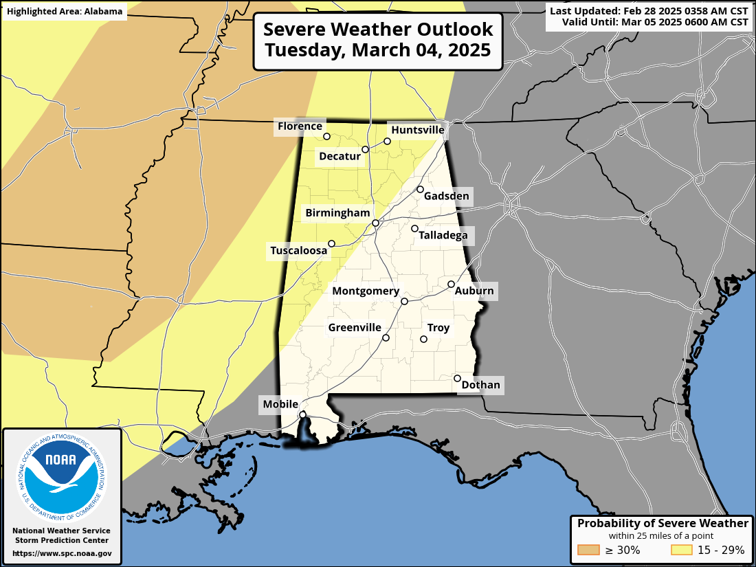
TUESDAY & WEDNESDAY – SEVERE WEATHER THREAT: Now, Tuesday is the day we need to keep a close eye on. As of the latest update, the Storm Prediction Center has placed nearly the entire northwestern half of Alabama under a Slight Risk for severe weather—valid through early Wednesday morning. While the southeastern half isn’t currently included, we may see a Marginal Risk added later on. What’s happening? Well, we’ll have a strong cold front approaching, and out ahead of it, warm, moisture-rich air will surge in from the Gulf. With highs in the upper 60s to upper 70s, increasing humidity, and plenty of instability, we’ll have the ingredients for strong to severe storms. The main threat will be damaging winds, associated with a squall line moving in late Tuesday into the pre-dawn hours of Wednesday. There’s also the potential for a few spin-up tornadoes embedded in the line. The big question: Will we see supercells ahead of the main line? If that happens, large hail and a few stronger tornadoes could be in play. Bottom line—this is shaping up to be a dynamic system, with gusty winds even behind the front. Stay weather-aware, and we’ll be fine-tuning the details over the next few days. Once the storms push out early Wednesday morning, skies clear quickly, and we’ll be left with a beautiful afternoon. Temperatures stay mild, with highs in the lower 60s to mid-70s northwest to southeast. We’ll get a better look at threat timing across the area as we get closer to the event.
THURSDAY — THE QUIET BEFORE THE NEXT SYSTEM: A calm day in between systems! Expect partly to mostly cloudy skies, with highs ranging from the mid-50s to upper 60s.
FRIDAY — ANOTHER FRONT APPROACHES: By midday Friday, we’ll see another cold front pushing in, bringing scattered showers that will spread east through the afternoon and evening. Rain could arrive as early as noon in western Alabama and continue into early Saturday morning. Now, there will be some instability, meaning thunderstorms are possible. It’s too early to say if severe weather will be a concern, but it’s something we’ll be watching closely.
So, enjoy this weekend, keep an eye on the severe threat Tuesday night, and stay tuned for updates on Friday’s system. We’ll keep you covered every step of the way. Y’all stay safe and have a great weekend!
Category: Alabama’s Weather, ALL POSTS, Severe Weather, Social Media, Weather Xtreme Videos