
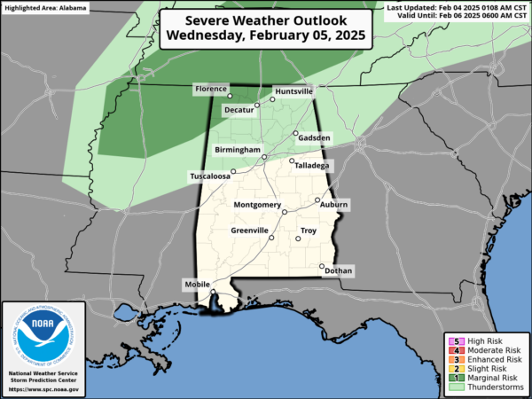
FEELING LIKE SPRING: Temperatures this week are running 15-25 degrees above average for the first week of February; highs are in the 70s with some 80s expected across central and southern sections of the state. We are dry again today, but tomorrow we will bring in a chance of scattered showers, mainly over the northern counties. Also tomorrow the Storm Prediction Center (SPC) has actually defined a low end “marginal risk” of severe thunderstorms for the northwest corner of the state tomorrow afternoon. There will be some surface based instability available, but wind fields are weak and the overall threat is low. The main threat would be gusty winds in some stronger storms if they develop.
Thursday and Friday some isolated showers are possible over the northern half of the state, but rain amounts, if any, will be light and very spotty, and most locations will remain dry. Highs these two days will continue to be in the 70s and 80s. This week’s weather will have a lot of people catching spring fever, but DON’T catch it, there remains a lot of winter left and we are not done with freezing temperatures in Alabama, just yet!
BIRMINGHAM ALMANAC: For February 4th, the average high for Birmingham is 57° and the average low is 36°. The record high is 77° set in 1927, while the record low is 4° set in 1996. We average 0.17” of precipitation on this date and the record value is 3.74” set in 1971.
USA BRIEF: Unsettled weather to persist across the Northwest U.S. through the middle of the week much colder temperatures and heavy snowfall across the Cascades and the northern Rockies. While an atmospheric river will continue to stream across northern and central California over the next couple of days with additional heavy rains and concerns for flooding. Also, a new storm system to bring a threat for light snow, sleet and freezing rain to portions of the Ohio Valley and the Mid-Atlantic region by Thursday. Finally, record high temperatures are expected across much of the Southern U.S. over the next few days.
THE WEEKEND: Saturday will be dry and warm with highs in the upper 70s and lower 80s. On Sunday, clouds begin to increase and we will bring the chance of rain back to the forecast ahead of a front that will start to bring cooler weather back to Alabama. Rain amounts will be light across the state on Sunday.
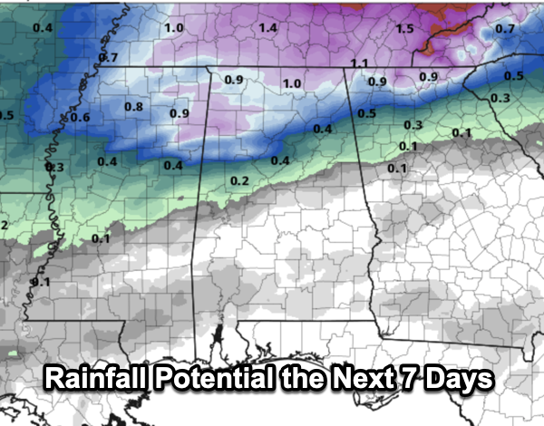
BACK TO AVERAGE: Highs drop into the 50s and 60s next week and lows fall into the 30s and 40s, which is right where temperatures should be for the second week of February. Though temperatures are trending downward, there are still no signs of any bitterly cold air for Alabama for the next ten days. Towards the middle of next week, the global models are showing a widespread rain event for much of the Deep South.
WORLD TEMPERATURE EXTREMES: Over the last 24 hours, the highest observation outside the U.S. was 115.2F at Warburton Airfield, Australia. The lowest observation was -68.1F at Delyankir, Russia.
CONTIGUOUS TEMPERATURE EXTREMES: Over the last 24 hours, the highest observation was 93F at Faith Ranch, TX. The lowest observation was -20F at Rugby, ND.
Category: Alabama’s Weather, ALL POSTS, Social Media