Lapplandsleden is a new 190 kilometer long hiking trail in the north of Sweden. There hasn’t been much information about it online yet since the opening of the trail so I decided it was about time to write a post about this amazing trail that shows why Lappland is such an amazing place to hike.
Note this post is about the Lapplandsleden summer hiking trail and not about the winter skiing trail. For information about this trail, please refer to Naturkartan.
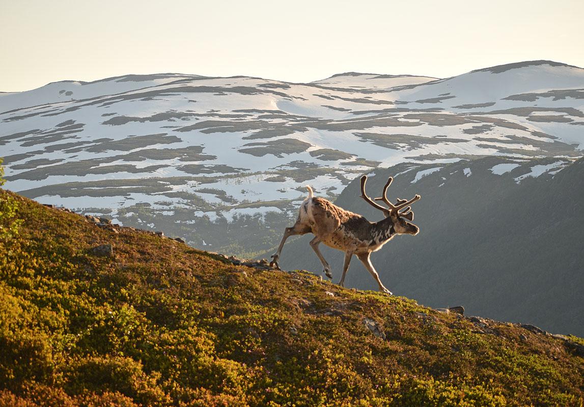
Coverphoto: Andreas Karlsson
Lapplandsleden is a 190 kilometer long thruhike from Hemavan in the north to Borgafjäll in the south of the province of Västerbotten län. The trail was officially opened after a few years of preparation in the fall of 2021 and the first summer season was in 2022. The name Lapplandsleden means the portal to Lappland, the northernmost region in Sweden (and technically also Finland). The increasingly more popular Gröna Bandet thruhike is also a part of Lapplandsleden.

Hiking Lapplandsleden
The Lapplandsleden is up until now very little walked, especially if you compare it to the famous Kungsleden. While I was out hiking various sections, I sometimes didn’t see anyone for a whole day. Sometimes I’d run into a few people, never more than a handful.
The trail is not technical but does require previous multi day hiking experience in the mountains. Although the trail is marked all the way, in various places the path is not visible yet as it takes more years to create a trail by humans rather than machines. In the forest sections I usually found that the trail was easy to follow, but on the mires and on the mountains, you usually just choose your own path from marker to marker.
In addition to this, there are various unbridged river crossings. Depending on the season, they may be between ankle to just above the knee. You should never attempt to hike Lapplandsleden before or during springflood, when the snow is melting and rivers swell.
You will also need to bring your tent as there are not enough cabins where you can spend the night and camping is required in many places. You will also occasionally do a few kilometers of road walking as the trail makers sometimes had to choose different valleys for making the trail in order not to cross private lands.

The sections of Lapplandsleden
The 190 kilometers can roughly be divided into the following sections. However, note that since you will have to camp at most places, you can basically just make your own sections if you decide to hike a longer or shorter period of time. The sections below have been made from road end to road end to make section hiking easier:
- Hemavan – Atostugan ca. 40 kms
- Atostugan – Granssjö ca. 49 kms
- Granssjö – Klimpfjäll – ca. 60 km
- Klimpfjäll – Borgafjäll ca. 40 km

Hemavan to Atostugan
On this section you will leave the mountain town of Hemavan and walk up to Jofjället. From here you will get the first panoramic view of the mountains. The trail passes many lakes where fishing is permitted and there’s a few wind shelters along the way where you can stop and have a fika.
Resupplies: in Boxfjäll

Atostugan to Granssjö
The section between Atostugan and Granssjö is probably the toughest section of the trail. You pass various mountain ridges including the highest point on Lapplandsleden: the Arefjället at 1.178 masl. This is also the highest point of a thruhike in Sweden!
This section also includes three big river crossings. The first one (coming from the north) is the biggest one and in high season, a pull out bridge may be placed. The best spots for wading are marked on the first and second river, on the third river you will have to find your own way.
About half way you will find Arevattnetstugan, a cosy cabin which sleeps four. Deavna rastskydd is a great stopover place for a break but sleeping is only allowed here in emergency. Once down at the parking in Vapstälven (which has a firepit and an outhouse) you’ll have to roadwalk to Gränssjö for about 8 kilometers. On this campsite you may be able to buy a few basic resupplies.
Resupply options: Granssjö

Granssjö – Klimpfjäll
From Granssjö, the hike continues to Klimpfjäll. You cross wide terrain and pass the dramatic Durrenskalet just before descending to the small village of Klimpfjäll. Note that the original route does not go through Klimpfjäll, if you wish to resupply you will have to detour for a bit. This section is also a part of the Norgefararleden.
Overnight options are in Åtnikstugan and Tjåkkelestugan. Durrenstugan can be used as an emergency shelter only. You can resupply in Klimpfjäll.

Klimpfjäll to Borgafjäll
The last section will lead you over the mountains from Klimpfjäll to Borgafjäll. Special about this section is the Slipsikstugan, which offers extended views and looks like a small piece of sugar from very far away. After the stugan there are literally hundreds of small bright blue lakes. This is a nice section with some mountain climbing before eventually reaching the south end of the Vasterbottensfjäll in the skiing town of Borgafjäll.

How to get to and from Lapplandsleden
Lapplandsleden is easily accessible by public transport. You can fly into Hemavan with PopulAir (6 days a week from Stockholm Arlanda, not on Saturday) or catch a bus from Umeå. Borgafjäll can be reached by bus from the town of Dorotea. Vilhelmina South Lappland Airport is a 45 minute drive away from Dorotea. There is also a public bus from Vilhelmina going to Klimpfjäll. The other section ends cannot be reached by public transport so you will need to arrange your own.

Food, drinking water and more
Make sure to stock up well on your chosen starting point as resupply options are limited. In Boxfjäll you can find a small shop which sells basic foods (mostly local foods such as dry meats) and in Klimpfjäll there is a little mountain store which sells basic food supplies. There is a small ICA Lanthandel in Borgafjäll and a large ICA supermarket as well as an outdoor shop in Hemavan.
You should be able to find enough drinking water along the way. Just be careful drinking from mountain lakes which have no visible inlet or outlet when there are reindeer around. Other than this, you can safely drink the water you will find along the trail.
Where to stay on Lapplandsleden
As mentioned, you will have to bring your own tent on Lapplandsleden. There’s a few cabins on the trail but they are basic and first come, first serve. Information about the payment is found in the cabin, it’s around 200 SEK per person/night and you are asked to leave the place clean and tidy and restock firewood that you have used up. The resting shelters cannot be used for overnight stays. In Gränssjö and Klimpfjäll you will find small campsites which also have cabins for rent. In Hemavan you will find plenty of accommodations (this one is my favorite) and in Borgafjäll there’s also a campsite. Hemavan does not have a campsite.

When to hike Lapplandsleden?
Ideally, you should hike Lapplandsleden between mid-July and mid-September. Note that before mid-July the higher sections may still have a lot of snow and the rivers may be impassable because of the snowmelt. Also you will disturb the reindeer calving when you want to hike earlier. Some lower sections may be accessible earlier in the season.
Although there may not be snow until October or even later, it’s not uncommon that there will be snowfall in mid-September already. Therefor, the best time to hike Lapplandsleden is between mid-July and mid-September.

Lapplandsleden or Kungsleden?
Although the Kungsleden and Lapplandsleden meet in Hemavan, they couldn’t be more different from one another. Kungsleden is a heavily walked trail and you will meet other hikers every few minutes. The huts along the way provide basic food supplies and are serviced most of the time. The Kungsleden is well marked and the trail is easy to follow.
Lapplandsleden is a totally different trail. There’s not many people hiking it (on the last count the best guess was about 100 per season) and there are no facilities along the way. As mentioned you will need previous hiking experience to safely hike on Lapplandsleden as well as have knowledge of hiking in the Swedish wilderness. Weather can change extremely fast, winds can be huge, rain can be hard and snowfall can occur at any time of the year. The Lapplandsleden has various big river crossings which may become impassable after heavy rain. Always bring emergency food for at least a day and also take an emergency locator beacon, such as a Garmin inReach as there is almost no mobile connection along the way.
Why hike Lapplandsleden?
To me, Lapplandsleden shows what Lappland is famous for: the amazing fjälls and the great layers in the landscape. You will have amazing views into far away lands and you will most likely encounter a lot of reindeer along the way. Hiking is slow (I made it up to 2.5 kms an hour on average) but well worth it. Chances are small you will meet a lot of people along the way. This is a wilderness trail as a trail should be.

Lapplandsleden hiking map
I suggest you’d get your hiking map beforehand to make sure you are well equipped before setting off. In Hemavan, you can buy the fjällkartan of this region at the Naturum Vindelfjällen or at the Sportsringen outdoor shop in the small shopping mall. Alternatively, you can buy them online at Calazo.
Book your trip to Sweden
If you’ve found this article useful, I hope you make use of the following links to book your trip to Sweden:
Hiking Lapplandsleden with a guide
There are currently no guided tours on Lapplandsleden, however, with my company Experience Hemavan, we offer you the opportunity to hike a section of the trail with my partner Andreas, who has built the trail. He’ll take you out to Atoklimpen and here you’ll hike on one of the easiest accessible alpine sections of Lapplandsleden.
Conclusion
I hope you found this article about Lapplandsleden useful. If you have any questions, feel free to reach out. My partner Andreas is one of the builders of the trail and will be happy to answer any questions about this amazing hike!
Want to read more about hiking in Sweden? Then make sure to read the following posts:
Alternatively you can go to my Sweden homepage for more than 50 articles about active traveling and hiking in Sweden.
This article contains affiliate links. If you make a purchase and/or reservation via such a link, we may receive a small commission at no extra cost to you. Thank you for considering!


![Grampians Walks – Ultimate Guide to the Best Hikes [2026]](https://som2nynetwork.com/wp-content/uploads/2026/07/Grampians-Walks-Hikes-Hero-336x220.jpg)
![It’s Monday! What Are You Reading? #imwayr [2.21.22] – Books. Iced Lattes. Blessed.](https://som2nynetwork.com/wp-content/uploads/2026/07/img_7364-336x220.jpg)
