Midday Nowcast: Some Clouds with a Weak Front Moving Through Alabama Today : The Alabama Weather Blog

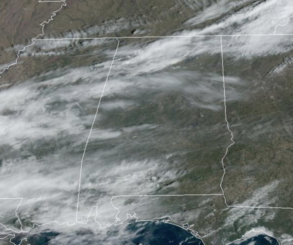
A weak cold front is moving through Alabama today, but with limited moisture it is mainly coming through in a dry fashion. We are seeing a more clouds as the front moves through and highs today are in the upper 60s and lower 70s. Tonight will be clear and chilly with lows falling into the upper 30s and lower 40s.
BIRMINGHAM ALMANAC: For February 27th, the average high for Birmingham is 62° and the average low is 41°. The record high is 82° set in 1962, while the record low is 15° set in 1963. We average 0.20” of precipitation on this date and the record value is 3.18” set in 1913.
ACROSS THE USA: Series of clipper systems to bring rain and snow showers to the Great Lakes, Appalachians, and Northeast through the early weekend. Above to well above-average temperatures expected to persist for most of the country to end the work week. Winds will also become gusty across most of the eastern two-thirds of the country this weekend. These winds and low humidity may increase fire weather concerns for portions of the Plains.
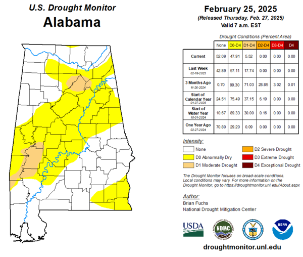
DROUGHT MONITOR: The newest update out this morning shows improvements in the drought conditions across the state. Almost 48% of the state is Abnormally Dry down from 57% last week. Moderate drought covers 5.52% of the state down from 17.74%. We still need a fair amount of rain to pull us out of the drought conditions.
TOMORROW AND THE WEEKEND: Expect sunshine in full supply all three days. Highs will be in the mid to upper 60s tomorrow and Saturday, but cooler air slips into Alabama on Sunday with highs mainly in the upper 50s. Lows will drop into the mid 30s by Sunday and Monday mornings.
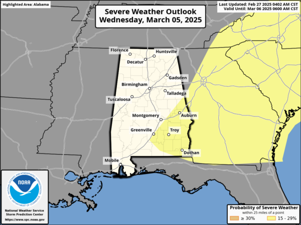
NEXT WEEK: Monday will feature more clouds than sun with highs in the 60s. On Tuesday, a few scattered showers are possible as a dynamic storm system takes shape to our west. Warm, southerly flow will allow temperatures to return to the low 70s. The Storm Prediction Center (SPC), continues to define a risk of severe storms for the Lower Mississippi Valley and that extends into much of Alabama as a band of will move through the state late Tuesday night into the pre-dawn hours Wednesday.
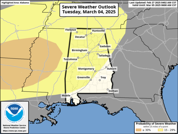
This line of severe storms will likely move through the state with potential for damaging winds and few isolated tornadoes. We still have several days to watch this system, and we will be much more specific about the event as it gets closer.
Rain amounts will be in the 1-2 inch range for the northern half of the state, with 1/2 to 1 inch for South Alabama.
Drier air will move into the state for the second half of the week being the storm system. High next week will be in the 60s and 70s.
WORLD TEMPERATURE EXTREMES: Over the last 24 hours, the highest observation outside the U.S. was 112.1F at Marree Aero, Australia. The lowest observation was -62.5F at Delyankir, Russia.
CONTIGUOUS TEMPERATURE EXTREMES: Over the last 24 hours, the highest observation was 95F at Indio, CA and Rio Grande Village, TX. The lowest observation was -23F at Peter Sinks, UT.
Category: Alabama’s Weather, ALL POSTS, Social Media