If you need easy vegan gluten-free breakfast recipes to start your day, look no further. I’ve got sweet, savory, and high protein vegan breakfast options, all gluten-free!

A vegan breakfast — even a gluten-free one — can be easy to make and just as satisfying as one that contains animal products. The recipes included below have options like omelets, frittatas, oats, granola, pancakes, waffles, and MORE!
And if you’re worried about getting enough protein, I’ve got a whole section of high protein, gluten-free vegan breakfasts, just for you. Use the table of contents above to jump to the section that you’d like to browse, or check out all of them!
A lot of gluten-free recipes include oats, which are naturally gluten-free. However, some brands of oats tend to be contaminated with gluten. If you are eating gluten-free because of an allergy or celiac, be sure to use certified gluten-free oats to be sure they won’t cause a reaction.
Kick off your day deliciously with these gluten-free, dairy-free breakfast options! Many of these recipes include nut-free and soy-free options, too.
Sweet Breakfasts
Think being vegan and gluten-free means you can’t have pancakes, waffles, and other amazing sweet breakfasts? These recipes prove that you can!

Gluten-Free Lemon Blueberry Pancakes
These sweet and zesty lemon blueberry pancakes are gluten-free and grain-free, yet they’re so light and fluffy! You are not going to believe that these almond flour pancakes are gluten-free and grain-free. Makes 6-8 pancakes(about 2 pancakes per serve)

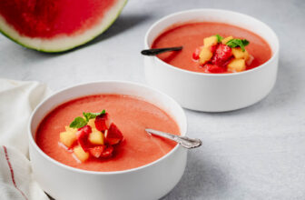
Lemon Curd Chia Pudding
Lemon Curd Chia Pudding. Easy 5 Ingredient Thick Lemon Coconut Milk Turmeric Pudding with Chia seeds. This zesty pudding is a refreshing treat for Summer. Serve with whipped coconut cream. Vegan gluten-free nut-free soy-free Recipe.

Cannoli Overnight Oats
Cannoli overnight oats are like an Italian dessert that you can eat for breakfast! They have an amazing mixture of flavors and textures from creamy, vanilla- and orange-scented oats, chocolate chips, and topped with crunchy cinnamon sugar tortilla chips

Vegan Banana Bread Oatmeal Bars with Cinnamon Crumb
Vegan Banana Oatmeal Bars topped with Caramelized Bananas and cinnamon crumb! They need just 1 Pan, are Glutenfree, refined sugar free, refined oil free! These Banana bread oat bars come together quickly and are perfect on the go snack or breakfast! Soyfree recipe, Nutfree option

Vegan Gluten Free Pumpkin Muffins

Vegan Gluten free Cinnamon Rolls Grain-free No Yeast

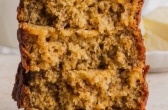
Banana Walnut Bread – Gluten free Banana Bread
This Banana Walnut Breakfast Loaf makes a great on the go breakfast. Bananas, spices and no added refined sugar. Free of Dairy, egg, corn, soy, gluten. Makes a medium bread pan.

Vegan Pumpkin Breakfast Cookies GF
For a fall-tastic breakfast treat that is easy to make, look no further than my pumpkin breakfast cookies! Gluten-free, refined sugar-free, oil-free and packed with nutritious add-ins like pumpkin puree, chia seeds, chopped nuts, and rolled oats.

Glutenfree Lemon Blueberry Waffles
These easy vegan gluten-free Lemon Blueberry Waffles are crispy on the outside, light and fluffy on the inside and perfect for brunch or breakfast! Super simple to make in one bowl. Makes 6 mini or 3 regular waffles

Vegan Banana Oat Pancakes (Gluten-free)

Date Caramel Maple Pecan Granola
This Date Caramel Maple Pecan Granola is lightly sweet and perfect for any time. Pecans, Oats, coconut, pumpkin and chia seeds and dried blueberries tossed in date caramel and baked to perfection. Vegan Glutenfree Soyfree Recipe. Can be nutfree. Makes a 16 oz mason jar worth

Snickers Baked Oats Vegan
This Vegan Snickers Baked Oatmeal recipe will be your new favorite breakfast meal prep! It takes only minutes of prep time and tastes like your favorite chocolate bar! Sweet, nutty, caramelly – the best way to start the day. Gluten-free Soyfree. Nutfree option

Vegan Apple Pie Baked Oatmeal
This easy Vegan Apple Pie Baked Oatmeal features a layer of baked oatmeal with crunchy nuts, chia seeds, and warming spices topped with delicious homemade apple pie filling. Plenty of cinnamon, and some maple syrup for sweetness – this baked oatmeal is perfect for a cozy morning

Blueberry Muffins Overnight Oats Vegan
These easy homemade Blueberry Muffins Overnight Oats are for all lovers of blueberry cakes and lemon blueberry muffins! A fun and delicious dessert-inspired vegan breakfast that is easy to make ahead of time – perfect for a busy morning! Gluten-free, oilfree, Nutfree option

Tiramisu Chia Seed Pudding
Decadent Vegan Tiramisu Chia Seed Pudding! Coffee Chocolate Chia pudding layered with creamy vanilla layer topped with whipped coconut cream and cocoa powder. Glutenfree Soyfree Nutfree
Savory Breakfasts
If you prefer to start your day with a savory meal, try these amazing options, like frittatas, scrambles, and even savory oats.

Chickpea Flour Frittata – Vegan Frittata Recipe
Chickpea Flour Frittata – Eggless Vegan Frittata Recipe. This Chickpea flour Vegetable frittata is filling, easy and delicious. Use the batter to make pancakes, crepes, crustless quiche. Vegan Glutenfree Soyfree Recipe Nutfree option

Pakora Waffles – Savory Chickpea Flour Waffles
Pakora Chickpea Flour Waffles are a fun savory vegan breakfast treat or snack! Veggie Pakora fritters are a staple at most Indian restaurants and now you can have them for breakfast – unfried! Gluten-free too! Soyfree Nutfree. Makes 8-9 mini waffles or 4-5 regular size

Savory Oats Hash – Indian Oats Poha Upma
Savory Oats Hash – Indian Oats Poha Upma. Savory Breakfast Oats with onions, veggies and nuts – Kanda Poha. Vegan Gluten-free Soy-free Yeast-free Recipe

Chickpea Flour Pancakes/mini Omelettes with Cauliflower and Shiitake mushrooms. Glutenfree Vegan Recipe
Easy Chickpea flour pancakes with grated cauliflower and shiitake mushrooms. These are fat pancakes made with a thick chickpea flour batter. Add more water for thinner batter and thinner pancakes. Makes 5 fat pancakes.

Indian Spiced Vegan Potato Quinoa Waffles
These easy Indian Spiced Vegan Potato Quinoa Waffles are inspired by my favorite Indian potato snack, Aloo Tikki! The quinoa adds nutrition and texture making them a savory brunch treat that is wonderfully filling! Makes 8-10 mini waffles

Mung Bean Sprouts Sauteed with Spices (Vegan Gluten Free Breakfast)
Mung bean sprouts sauteed with spices. Delicious, quick and healthy, a great way to start the day. Vegan and Gluten Free Breakfast.

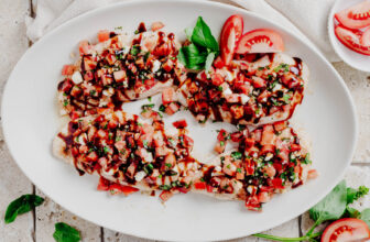
Chickpea Tofu Breakfast Scramble with Smoky Bits

Savory Granola Bars
Hearty, satisfying Doritos Nacho Spice Savory Granola Bar! Don’t want sticky sweet snack, make this nutty seedy nacho cheesy crisp snack bars! They almost have the texture of shortbread crackers with lots of nacho cheesy flavor. Also Gluten-free
High Protein
Whether you’re an athlete or simply want to up your protein intake, these high protein vegan breakfasts are what you need. They’re all gluten-free!

Easy Scramble Seasoning Mix and the Best Ever Tofu Scramble

Vegan Omelet with Mung Bean Egg Substitute

Moong Egg Sandwich
Moong Egg Sandwich! The viral TikTok egg sandwich made with mung bean egg stuffed with spinach and cheese! Vegan Soyfree Nutfree recipe.

Baklava Overnight Oats
Baklava overnight oats are super easy and super delicious made with simple, everyday ingredients. You’ll top them with a nut mixture which will remind you of baklava filling. It just has an amazing flavor and texture! Glutenfree Soyfree

Vegan Breakfast Quesadilla with Smoky Bacony Potatoes
For a savory vegan breakfast make this Breakfast Quesadilla with Smoky Potatoes, Fried Tofu and Eggy Hummus. It can be made ahead of time and assembled right before serving! Meal prep win! Gluten-free option included.

Chickpea Flour Scramble Breakfast Recipe
Easy peppery Chickpea flour Scramble. Soy-free Breakfast Scramble. Make with lentil flour or lentil batter for variation. Vegan Gluten-free Soyfree Recipe. When doubling the recipe, use a tbsp or so less water.

Sweet OR Savory Baked Oatmeal Mix
Don’t you love baked oatmeal? It’s so hearty and versatile! You can make it sweet or savory using whatever ingredients you have in your kitchen, but did you know that it also makes a great holiday gift? This baked oatmeal mix is a mason jar gift that’s a perfect stocking stuffer, coworker gift, hostess gift, etc.

Lentil flour pancakes (Moong Dal Chilla) with Spinach
These easy vegan moong dal chilla made with moong flour( yellow lentil pancakes) have sesame seeds and spinach. They are great to serve alongside Indian food or as a wrap or savory pancake. No soaking lentils needed as we use lentil flour. Gluten-free! And you can also make waffles with the batter

Sriracha Quinoa Millet Cranberry Orange Peanut Granola/Trail Mix. Glutenfree Spicy Granola
This Spicy granola with Sriracha Millet Quinoa is a very addictive savory, sweet and spicy granola with puffed millet, quinoa, peanuts, cranberries and orange zest! Savory granola.

Red Lentil Granola with Coconut and Cranberries
Sweet, crunchy, protein-packed red lentil granola with coconut and cranberries is allergy-friendly and has 11 grams of protein per serving! Serve it just like you would any other granola.
Frequently Asked Questions
Yes! Gluten comes from plants, so it is vegan. There are reasons that people avoid gluten, such as an allergy or celiac, which is why I created this collection of gluten-free vegan breakfast recipes.
Any of the recipes in this collection are perfect for that situation! You can choose from breakfasts like pancakes, waffles, scrambles, frittatas, and more.