Tons of sunshine in the Alabama sky today as the clean-up from the weekend storms continues. Highs this afternoon are ranging from the lower to mid 60s. Tonight will be clear and cold with upper 30s and lower 40s. Then tomorrow, a terrific Tuesday of weather with highs surging into the low and mid 70s under abundant sunshine.
BIRMINGHAM ALMANAC: For March 17th, the average high for Birmingham is 67° and the average low is 45°. The record high is 86° set in 2012, while the record low is 28° set in 1988. We average 0.18” of precipitation on this date and the record value is 3.42” set in 1920.
ACROSS THE USA: Heavy snow over the Sierra Nevada Mountains/ Northern Rockies on Monday and Northern/Central Rockies on Tuesday; light to moderate snow from the Central Plains to the Upper Great Lakes on Tuesday into Wednesday morning. Temperatures will be 15 to 25 degrees above average over parts of the Central Plains and adjacent regions. There is a Critical Risk of fire weather over the parts of the Central/Southern High Plains on Monday and Extreme Risk over the Southern High Plains.
WEDNESDAY NIGHT COLD FRONT: Wednesday will be dry and warm day with highs surging into the upper 70s and lower 80s. Wednesday night, a cold front will bring a band of rain and storms through the state.
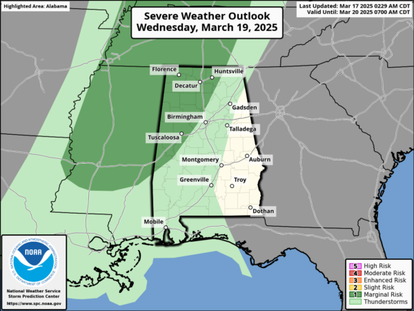
The SPC has defined a low end “marginal risk” (level 1/5) of severe thunderstorms for areas north and west of Birmingham. As the front swings through, a few storms along the front could produce small hail and gusty winds, but with little surface based instability and weak dynamic support the overall threat is low.
COLD FIRST DAYS OF SPRING: The spring equinox occurs at 4:01AM CDT Thursday morning, meaning the official arrival of spring. This is when the sun is directly over the equator. As we start spring, much colder air rolls into the Deep South behind the Wednesday night front. Expect a chilly north breeze Thursday with highs only in the mid 50s with a mostly sunny sky. Friday morning, we are looking at lows in the 28-35 degree range over the northern half of the state, where frost is likely. Colder spots will see a late season freeze. Friday will feature sunshine in fully supply with afternoon high generally in the mid 60s.
THE ALABAMA WEEKEND: Model madness between the global model output, meaning we have very low confidence forecast. The American GFS model suggests most of the weekend will be dry, followed by a round of showers and storms Sunday night. But, the reliable European global model suggests some rain on Saturday, followed by a dry day Sunday.
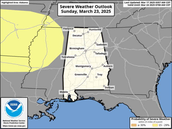
We note the SPC has defined a risk of severe weather just to the west of Alabama for Sunday. Again, in the coming days we should begin to see model consistency, giving us higher confidence in our forecast. It will be mild weekend with highs in the low and mid 70s both days.
WORLD TEMPERATURE EXTREMES: Over the last 24 hours, the highest observation outside the U.S. was 112.5F at Tillabery, Niger. The lowest observation was -82.1F at Vostok, Antarctica.
CONTIGUOUS TEMPERATURE EXTREMES: Over the last 24 hours, the highest observation was 92F at Ochopee, FL. The lowest observation was 3F at Cadillac, MI.
Category: Alabama’s Weather, ALL POSTS, Social Media