

The precision agriculture (also known as precision farming and precision ag) industry has gained
a lot of press and attention over the past decade. Technology advancements including global positioning
systems (GPS) satellites, wifi, drones, computer vision, LIDAR, big data processing and artificial intelligence
have all contributed to the advancement and increasing importance of precision ag.
Precision agriculture is a key component to increasing the world’s food supply and reducing greenhouse gas emissions. The
World Economic Forum estimates
that if 15 to 25% of the globe’s farms were to adopt precision agriculture techniques, then
global crop yields could increase by 10 to 15% and greenhouse gas emissions and water would decrease by
10% and 20%, respectively.
What Is Precision Agriculture?
Precision agriculture
can be best characterized as farming management based on observing, measuring and responding to field
variability in crops. High level, it enables farmers to give special attention to smaller, more defined
tracks of land by using and analyzing data gathered from equipment and sensors.
It enables farmers and managers to do more with fewer resources — increasing productivity,
yields and quality, while reducing labor costs, time and inputs such as fertilizers, fungicides, etc.
Precision agriculture helps farmers understand the underlying dynamics of their land, optimize crop yields and
utilize inputs (water, fertilizers, herbicides, etc.) more efficiently.
Farmers are able to visualize
maps of the terrain and see areas that may require more or less attention or application. Precision ag software collects
data from sensors and equipment (such as cameras, GPS, drones, LIDAR, IoT sensors, etc), then maps
the field conditions. A large 1,000-acre field likely has many different patches or spots that require varying
levels of treatment and attention. Tending to these areas required more guesswork and time before the advent of precision ag.
Tools used in precision agriculture today enable farmers to map their fields rapidly, save snapshots to see how
their fields evolve over time and weave their analytics data into their machinery such as tractors, combines,
sprayers, applicators, etc.
to tend to the fields and crops more efficiently.
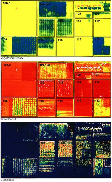
Image above shows sample maps produced by precision agriculture to analyze vegetation density, water deficit and crop stress.
Machine Learning, Artificial Intelligence & Precision Farming
Machine Learning and Artificial Intelligence
have become hot topics over the past few years. The rise of cloud computing
and faster processors have enabled companies to process, analyze and report large quantities of data in seconds and minutes.
Machine learning and artificial intelligence make sense of data by analyzing millions to billions of data points and
finding meaningful relationships and drivers.
Precision agriculture is a natural fit for advanced analysis such as artificial intelligence. Data points
collected in the field can include water levels, soil conditions, crop health, temperature, humidity,
crop color, crop height, signs of infection, pests, temperature, and more. Smart computer algorithms ingest these
data and then make intelligent recommendations to optimize crop yield and applications.
Internet of Things (IoT) is another development that will fuel precision agriculture applications. IoT devices are
plugged into the internet 24/7, and can report real-time data to your cloud database. IoT devices
help farmers keep a live pulse on their crops and fields.
Equipment & Machinery Used For Precision Agriculture
Smartphones and tablets
Mobile devices are one of the most common items used in precision ag. Applications can map fields, track
animals, update weather information and more. These applications tend to be very affordable.
Global Satellite Positioning System (GPS)
GPS is an essential part of precision farming — it enables precise recording of coordinates (latitude and longitude)
to accurately map and pinpoint areas of interest. GPS is widely used on drones, sensors, tractors, and other
farm machinery. GPS enables machinery to operate autonomously — for instance, a farmer can plugin GPS coordinates
for a path that a drone or tractor can follow. The drone or tractor then can navigate the course by itself using GPS.
Precision agriculture uses GPS to map the location of the device or sensor as it collects data. It then aggregates
all of these locations and data to create a visual geographic map.
Drones
Drones are unmanned aerial craft capable of flying and maneuvering at low altitude and low speed in order to capture
data such as images, temperature, LIDAR, humidity, etc. Drones can be controlled by remote control, or by a GPS
system. Drones can quickly map and collect field data at a low cost.
Drones store data on a medium such as an SD card, or by transmitting it electronically back to a base station. Some companies offer
professional drone mapping services to farmers.
Larger drones are now capable of performing tasks such as precision spraying, cutting/trimming, and picking. This technology
is not yet widespread, but it will be more common in the future.
Remote Sensors
Using remote sensors helps in collecting different farm data without physically touching anything.
Remote sensors have different uses on the farm and are another very important piece of equipment for precision farming.
With remote sensors, farmers can better identify crops and make good decisions.
Remote sensors can also detect animals, plants, soils, and notice other elements on the farm.
They can be very helpful in identifying pests because they can sense different emissions from pest-infected
crops in comparison to healthy crops. Some other things for which remote sensors can be
used include monitoring weather conditions, estimating moisture in the land, mapping
resources on the farm, and estimating crop yield.
Variable Rate Technology (VRT)
VRT helps adjust and apply precise and measured quantities of fertilizers, herbicides, seeds, water and other
items in the field.
It reduces waste and increases yields. VRT is usually used when applying fertilizers, weeding, sowing, or irrigating.
GPS is required for VRT to properly work, in addition to specialized software. VRT is helpful in many ways — for example,
when seeding, this technology ensures that seeds are sowed only then when it is needed.
Data Management System
Precision agriculture produces vast quantities of data in the form of numbers, images and text. Data management
systems help store, process, organize and analyze these data sets. Typically when data are gathered from
sensors they are in raw format — they need to be processed and analyzed to add value.
A good analogy of data processing is an apple and apple pie. When you collect the data it is like collecting apples.
If you want a sweet, delicious dessert
then you will need to process those apples to make apple pie. The act of processing the apples includes washing and
cutting them, combining them with other ingredients such as crust and sugar, then baking. The same concept applies
to your precision agriculture data.
Satellite Cameras
As the private industry makes satellite launches more affordable, many services are now available to take pictures of
farmland from outer space. One such company is Planet Labs.
These high-res images can be taken at regular
intervals (daily, weekly or monthly), and then analyzed.
Conclusion
Precision agriculture is valuable and here to stay. The industry will continue to grow and become more important
to our farming techniques. New developments such as artificial intelligence and labor-capable drones will further
integrate precision agriculture into farming best practices.
Resources
Find Similar Articles By Topic