Midday Nowcast: Soggy End To The Workweek; Wonderful Weekend Weather : The Alabama Weather Blog
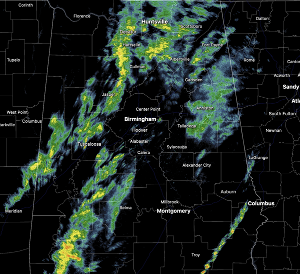

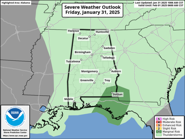
FINAL HOURS OF JANUARY: A cloudy and wet start to this final day of January as a cold front swings through the state, but the rain is relatively light and will be winding down through the afternoon and evening hours. There still could be a few strong storms across Southeast Alabama this afternoon as some storms could produce gusty winds. The overall threat is relatively low down that way. Temperatures this afternoon are in the upper 50s and lower 60s.The clouds will gradually decrease overnight with lows in the lower 40s.
BIRMINGHAM ALMANAC: For January 31st, the average high for Birmingham is 56° and the average low is 35°. The record high is 75° set in 1957, while the record low is 5° set in 1966. We average 0.17” of precipitation on this date and the record value is 2.66” set in 1915.
ACROSS THE USA: A strong weather system will bring the potential for flash flooding, severe thunderstorms, strong to locally damaging non-thunderstorm winds, and high elevation snow to the Hawaiian Islands. Precipitation will overspread most of the eastern third of the country. A prolonged atmospheric river will bring low elevation rain and mountain snow to the Pacific Northwest and California into the Rockies.
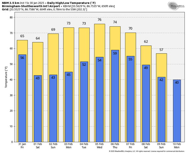
WONDERFUL WEEKEND WEATHER: For the weekend, it will be the best weekend of weather so far in this young year, incredible weather for the first weekend of February. Expect mostly sunny mild days and clear cool nights; highs in the low to mid 60s tomorrow and upper 60s to low 70s Sunday, lows will be in the 40s.
SPRING-LIKE WEATHER: The dry and very pleasant weather continues for much of next week, with models trending warmer and warmer with highs in the 70s expected most days across the state. We could even see some record highs by midweek and it will be a true taste of spring, but understand there is a lot of winter left, so don’t be catching spring fever just yet! The first half of the week will be dry, with the chance of some rain returning at times for the second half of the week.
WORLD TEMPERATURE EXTREMES: Over the last 24 hours, the highest observation outside the U.S. was 113.5F at Ravensthorpe Hopetoun, Australia. The lowest observation was -63.9F at Ilirnej, Russia.
CONTIGUOUS TEMPERATURE EXTREMES: Over the last 24 hours, the highest observation was 85F at Everglades City, The lowest observation was -31F at Peter Sinks, UT.
Category: Alabama’s Weather, ALL POSTS, Social Media