ACTIVE DAY: A flood watch has been issued for parts of Central and Northeast Alabama through tonight, where additional rain amounts of 2-3 inches are possible. Occasional rain will continue statewide through tonight, and we also have the risk of a few strong to severe thunderstorms this afternoon and tonight. SPC has defined a “slight risk” (level 2/5) of severe thunderstorms as far north as Tuscaloosa, Birmingham, and Jacksonville… a “marginal risk” (level 1/5) is in place as far north as Huntsville.
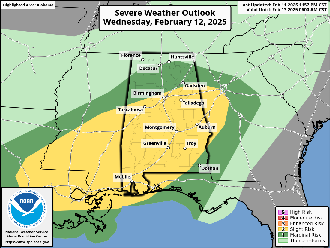
We still believe the highest risk of severe storms will be over the southern half of Alabama this afternoon and tonight. There is a well defined warm front over South Alabama this morning, and the northward extent of the severe thunderstorm risk will be defined by the position of this front. High resolution models suggest the front will have a hard time moving past U.S. 80 tonight; this will keep the air cool and stable over the northern half of the state if this idea is correct.
Storms over South Alabama this afternoon and tonight will be capable of producing strong winds, and a few isolated tornadoes are possible. For those in North Alabama, as always you still need to pay close attention to the weather in case the warm front moves farther north. Temperatures today will range from the low to mid 50s across the Tennessee Valley to the 70s over the southern counties.
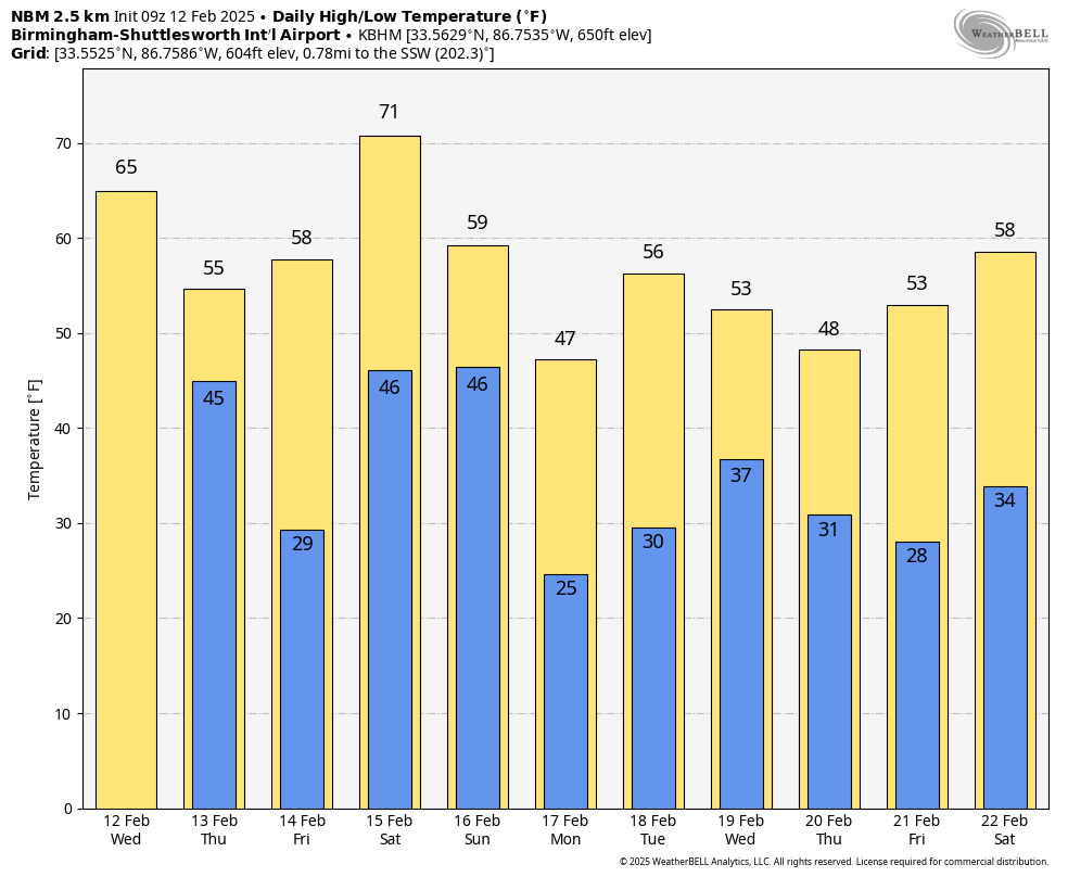
Rain and storms will end early in the day tomorrow, followed by a clearing sky. A freeze is likely early Friday morning for North Alabama; the day will be mostly sunny with a high in the 58-64 degree range.
STORMY WEEKEND: A dynamic weather system will bring another threat of severe thunderstorms to Alabama over the weekend. SPC has defined a risk for most all of Alabama, with an enhanced risk for the western counties of the state.
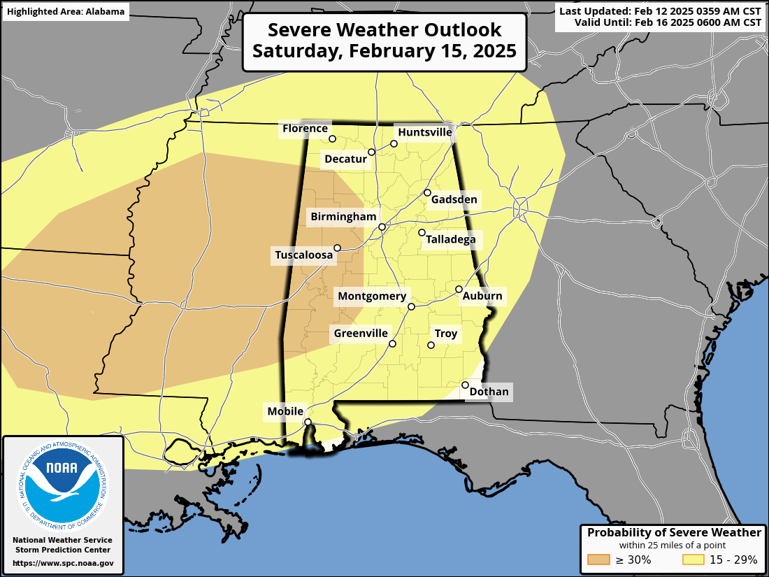
Saturday will be a mild and windy day with temperatures reaching the 70s. Much of the day will be dry… then an organized batch of rain and storms will arrive Saturday night into the pre-dawn hours Sunday. All modes of severe weather will be possible, but we need to get today’s system out of here before we can be specific about the magnitude of the event, the timing, and the tornado threat.
Sunday will be cooler and breezy with a clearing sky, and a freeze is likely for most of the state by Monday morning.
NEXT WEEK: The week will be cool with highs in the 40s and 50s; global models continue to suggest a big rain maker at mid-week (either Wednesday or Thursday). See the video briefing for maps, graphics, and more details.
ON THIS DATE IN 1958: Snow blanketed northern Florida, with Tallahassee reporting a record 2.8 inches. A ship in the Gulf of Mexico, 25 miles south of Fort Morgan, reported zero visibility in heavy snow on the afternoon of the 12th.
Look for the next video briefing here by 3:00 this afternoon… enjoy the day!
Category: Alabama’s Weather, ALL POSTS, Weather Xtreme Videos