Special Sunday Evening Weather Briefing Video: Very Cold Week Ahead, Wintry Precip North Alabama Tuesday Night

It has been a stormy 24 hours across Alabama, but things have turned sharply colder today. Let’s dig into the forecast…
SATURDAY RECAP:
Saturday was windy and cool across Central and North Alabama as a strong cold front pushed through. Widespread wind damage was reported overnight, with several areas of concentrated damage to be surveyed in the coming days. An EF1 tornado was has been confirmed at Newbern in Hale County. The tornado moved into Perry County before lifting. Highs today occurred just after midnight, as temperatures fell through the day at most locations. Readings have dropped into the 30s and 40s late this afternoon.
CURRENT CONDITIONS:
A deck of low clouds persists across Central Alabama behind the cold front as colder air continues to filter into the region. Winds remain breezy but will gradually subside tonight. Over North Alabama, skies are expected to clear overnight, with mostly clear conditions by Monday morning.
TEMPERATURE PLUNGE TONIGHT:
Temperatures will fall sharply tonight, with lows dropping into the 20s across Central and North Alabama. Lingering clouds over northern areas could slightly moderate temperatures into the upper 20s, while most other locations will see lows in the low to mid-20s. Winds will decrease but remain light from the north and northwest.
CHILLY AND QUIET MONDAY:
Monday will be a dry and chilly day with high pressure settling over the region. Highs will range from the upper 40s to mid-50s, with much lighter winds than today. Conditions will remain quiet through Monday night, with lows dipping back into the mid to upper 20s.
WINTRY MIX POSSIBLE TUESDAY NIGHT:
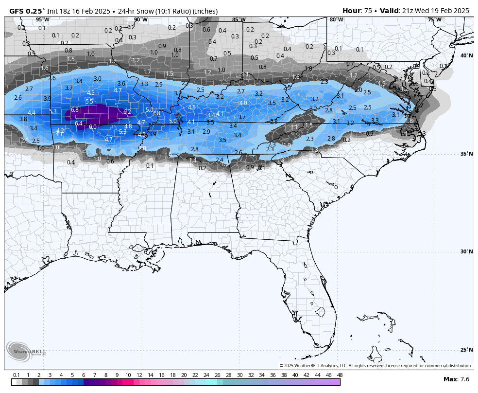
Tuesday night into Wednesday brings a potential for wintry weather. A Gulf low will pass to our south, drawing moisture into the colder air already in place. A rain and snow mix is likely across northern areas, especially along and north of I-59. Some light accumulations, up to half an inch, are possible, particularly along and west of I-65 and into southern middle Tennessee. The good news is that temperatures should quickly rise above freezing by late Wednesday morning, limiting the window for impacts.
DEEP FREEZE MIDWEEK:
Following the system, strong cold air advection will bring frigid conditions to the region. Lows on Wednesday night will plunge into the teens to low 20s, with Thursday’s highs struggling to reach the freezing mark, especially north of the Tennessee River. Another very cold night is expected Thursday, with lows in the mid-teens. This cold pattern will persist into the weekend, although a slight warming trend is possible by Saturday.
WEEKEND OUTLOOK:
The extended outlook remains dry through the end of the week. Highs will rebound into the upper 40s and lower 50s by Saturday, with lows moderating into the 20s and 30s.
SAFETY REMINDER:
With the incoming cold, it’s a good time to remember the four Ps: People, Pets, Pipes, and Plants. Also, if using space heaters, ensure they are placed safely to avoid fire hazards.
WINTER PATTERN INSIGHT:
This pattern is a classic setup for winter weather, with a Gulf low bringing moisture and an Arctic high delivering the cold air. While the snow risk is limited, the cold will be the bigger story as temperatures drop well below normal for several days.
ONE YEAR AGO:
Record low maximum temperatures were set at Huntsville (21F), Muscle Shoals (22F), Birmingham (27F) and Tuscaloosa (31F). The Tuscaloosa and Birmingham previous records were set in 1977 with 31F and 30F respectively. Huntsville’s previous record of 24F was set in 2009 and the Shoals record of tied the record set in 1927.