

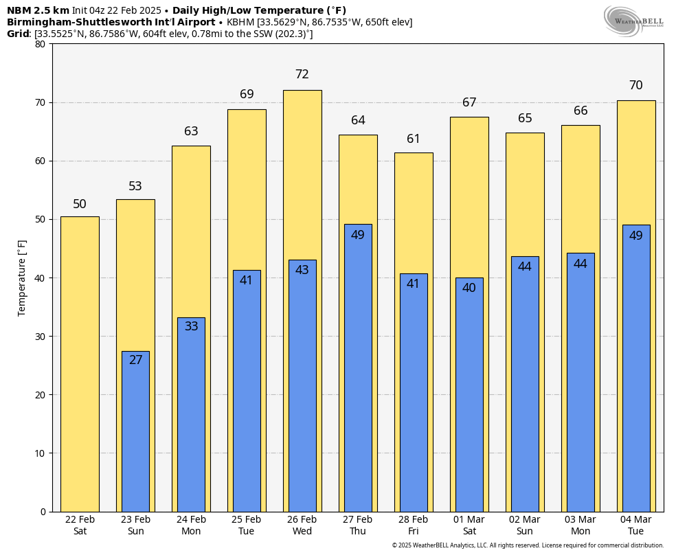
Forecast highs and lows from the National Blend of Models valid through March 4th.
A dynamic weather pattern is setting up this week, featuring a mix of chilly mornings, warming trends, and periodic rain chances. Here’s a detailed look at what to expect:
Saturday:
High pressure remains dominant, delivering a clear and seasonably cool winter day. Morning lows will range from the lower 20s to lower 30s, but efficient daytime heating will push afternoon highs into the upper 40s to lower 60s. Expect a mix of sun and clouds with calm conditions—typical for this time of year.
Sunday:
The day begins with some sunshine, but cloud cover will increase through the afternoon ahead of an approaching disturbance. Scattered showers are expected to develop, mainly across the southern half of the state by mid-to-late afternoon. Temperatures will be milder, ranging from the lower 50s to lower 60s. Those with outdoor plans should be prepared for possible wet conditions later in the day.
Monday:
Early morning showers will linger but will clear out quickly, with improving conditions by midday. A noticeable warm-up follows, with highs reaching the 60s areawide. Overall, a much milder and drier start to the workweek.
Tuesday:
A significant warm-up continues, with mostly sunny skies and unseasonably warm temperatures. Highs will range from the mid-60s to mid-70s, more typical of early spring than late February.
Wednesday:
Another warm day with highs in the upper 60s to mid-70s. Expect increasing high clouds during the day, with more substantial cloud cover moving in by evening as the next frontal boundary approaches. Showers are likely to develop across North Alabama by late evening into the overnight hours.
Thursday:
A few early morning showers are possible, primarily in northern parts of the state. However, conditions improve through the day, with skies becoming partly to mostly sunny. A slight cooldown follows, with highs ranging from the upper 50s to lower 70s—still above average for this time of year.
Friday:
A quiet and seasonable end to the week. Mostly sunny skies prevail, with highs in the mid-50s to upper 60s, the coolest northeast and warmest southwest.
Summary:
While temperatures fluctuate, the overall trend favors above-average warmth with intermittent rain chances Sunday and again late Wednesday into early Thursday. No major cold outbreaks or severe weather are expected at this time. Stay weather-aware and enjoy the week ahead!
Category: Alabama’s Weather, ALL POSTS, Social Media, Weather Xtreme Videos


