

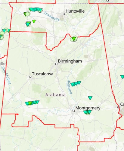
The image above is a map of the Birmingham and Huntsville WFO’s with the tracks of the tornadoes that have been confirmed from last weekend. An additional tornado has been confirmed in Moundville, but has not yet been added to this map. Here are the details from the Moundville tornado:
Rating:                 EF0
Estimated Peak Wind:    75 mph
Path Length /statute/:  1.62 miles
Path Width /maximum/:   150 yards
Fatalities:             0
Injuries:               0

Start Date:             02/16/2025
Start Time:             12:33 AM CST
Start Location:         1 WSW Moundville / Hale County / AL
Start Lat/Lon:          32.9881 / -87.6541

End Date:               02/16/2025
End Time:               12:36 AM CST
End Location:           Moundville / Hale County / AL
End Lat/Lon:            32.9912 / -87.6265

Survey Summary:
A National Weather Service damage survey in Moundville revealed
an EF-0 tornado that occurred early on February 16. The tornado
began in a wooded area near Green Ridge Rd and moved east-
northeastward. Along Power Loop Rd, several pine trees had tops
snapped off and large limbs broken. A few other pines were
uprooted near a residence, and a barn sustained roof damage. A
large tree fell on the backside of a house at 2nd Ave and Maple
Leaf Lane, causing significant damage. Between Maple Leaf Lane
and Jamestown Circle, several tree limbs were snapped and a
trampoline was flipped. Tree damage continued through another
wooded area to just west of the Hale County High School football
field, where the path appeared to end just west of Highway 69.


