
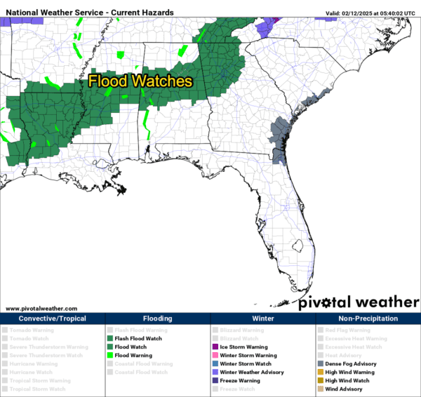

STAY ALERT: FLOOD WATCHES IN EFFECT ACROSS CENTRAL AND NORTH ALABAMA
Heavy rain is making its mark across Alabama tonight, prompting the National Weather Service to issue Flood Watches for a wide swath of the state. These watches highlight the potential for dangerous flooding conditions through late Wednesday night. Here’s what you need to know to stay safe.
…WHERE ARE THE FLOOD WATCHES IN EFFECT?
- Central Alabama: This includes areas like Birmingham, Tuscaloosa, Hoover, Gadsden, Anniston, and Alexander City. Counties under the watch span from Lamar and Fayette in the west to Chambers and Randolph in the east.
- North Alabama: The watch covers Cullman, Marshall, Jackson, and DeKalb Counties—home to cities like Scottsboro, Fort Payne, Guntersville, and Cullman.
…WHAT’S CAUSING THE CONCERN?
The region has already soaked up 1 to 2.5 inches of rain, especially in Northeast Alabama. Forecasts call for an additional 1.5 to 2.5 inches over the next 24 hours. This could overwhelm rivers, creeks, and drainage systems, leading to:
- Rapid rises in rivers and streams
- Flash flooding in low-lying areas
- Urban flooding, especially in poor drainage spots
…WHAT SHOULD YOU DO NOW?
- Stay Weather Aware: Keep up with the latest forecasts and be ready for Flood Warnings, which mean flooding is imminent or already occurring.
- Know Your Risk: If you live in a flood-prone area, prepare now. Review your evacuation routes and emergency plans.
- Turn Around, Don’t Drown: Never drive through flooded roads. Just 6 inches of moving water can knock you off your feet, and a foot of water can carry away most vehicles.
…STAY CONNECTED:
- Flood Safety Tips from the NWS
- Follow your local NWS office:
Birmingham |
Huntsville - Monitor river levels and rainfall trends in real-time.
- Stay tuned to the Blog.
As the rain continues to fall, remember—flooding can happen fast. Stay alert, stay safe, and keep an eye on the skies.


