
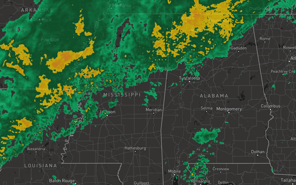

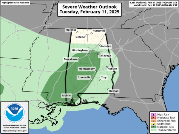
RAIN, SOME STORMS TODAY: Rain has been ongoing through the morning hours and it will continue to expand in coverage and intensity as we head through the afternoon hours. The SPC has introduced a “low end” marginal risk (level 1of 5) of severe storms today as some stronger storms this afternoon could have gusty winds with a non-zero tornado threat.
Temperatures today are ranging from the upper 50s to the north to the lower 70s down south. Not a lot of instability for storms to work with, but enough that a few strong storms are possible.
BIRMINGHAM ALMANAC: For February 11th, the average high for Birmingham is 58° and the average low is 38°. The record high is 79° set in 1999, while the record low is 14° set in 1981. We average 0.17” of precipitation on this date and the record value is 1.61” set in 2024.
MORE RAIN, SOME SEVERE STORMS TOMORROW: A warm front will lift north tomorrow ahead of an approaching cold front meaning the rain continues tomorrow and it could be heavy at times. Tomorrow morning will likely start off wet and stormy across Alabama as the warm front lifts north. Then late tomorrow afternoon and evening, some strong to severe storms are expected to develop as the cold front moves into the state. Some severe storms are expected and the SPC has a “slight risk” (level 2/5) of severe thunderstorms for much of West Alabama, with the rest of the state is in a “marginal risk” (level 1/5).
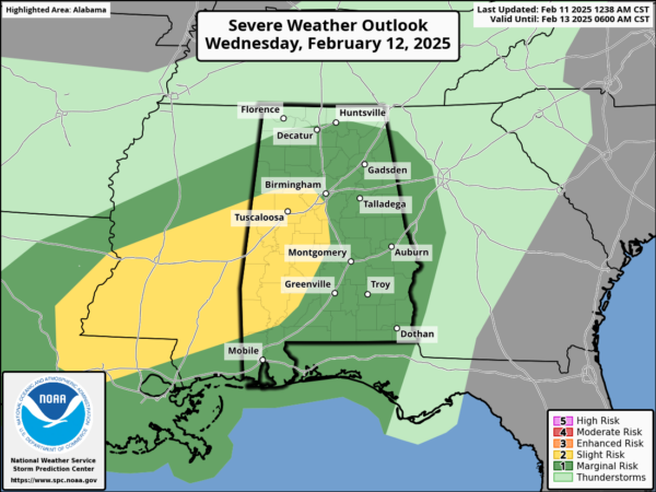
Stronger storms tomorrow afternoon and night are likely to produce strong, gusty winds. A brief, isolated tornado or two can’t be ruled out as well, mainly over the southern half of the state where surface based instability will be available. The main window for the storm threat will come from 4PM Wednesday through 2AM Thursday. With storms finally exiting the southeast corner of the state by 7or 8AM Thursday.
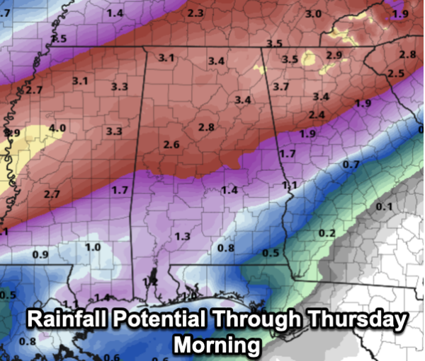
Rain amounts of 2-4 inches are likely over the northern counties of Alabama over the next 48 hours and most South Alabama communities will see 1-2 inches of rain. Flooding issues are possible, and especially stream in river flooding in the coming days.
CALL TO ACTION: Even though this is not a major severe weather event for the state, we should review severe weather safety protocols as we get closer to the core of our severe weather season in March, April, and May. With any severe weather event, but especially an overnight event, be ready to act immediately…Have multiple, reliable ways to receive severe weather alerts, NEVER, ever, ever rely on a outdoor siren. Every Alabama home and business needs a NOAA Weather Radio (the most popular model is the Midland WR-120, which is sold in most local big box retailers). The other way is your phone…be sure emergency alerts are enabled (look under settings, and notifications), and install the free ABC 33/40 Weather app.
Know the safe place in your house, and in that safe place have helmets for everyone. Bicycle helmets and batting helmets work well. We also recommend portable air horns and hard soled shoes for everyone. If you live in an apartment complex, you can’t be above the first level. Shelter with a friend on the ground level, or ask management if they can open the clubhouse during a tornado warning.
If you live in a mobile home, you cannot stay there during a tornado warning, they offer little to know protection from severe storms. Know the location of the nearest shelter, or business that is open 24/7. Know how to get there quickly.
THURSDAY/FRIDAY: Drier air moves into the state Thursday and we expect a clearing sky with highs in the 50s. Friday will be rain-free and mostly sunny with afternoon highs in the low 60s. Lows will be in the 30s with some 20s expect Friday morning.
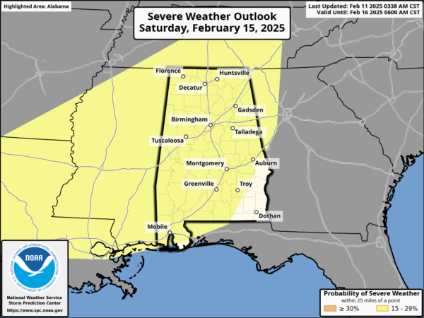
MORE ACTIVE WEATHER: A dynamic system will bring rain and thunderstorms back to Alabama Saturday afternoon, continuing Saturday night. The SPC has much of the state in a severe weather risk in their “Day 5” outlook, which runs from Saturday through 6AM Sunday. Another warm front will surge northward Saturday as temperatures rise into the 70s Saturday, and the air becomes unstable ahead of the approaching system. The main threat of severe storms and heavy rain will come Saturday night into the pre-dawn hours Sunday. Too early to know the magnitude of the threat, the timing, and the tornado risk. Let’s get through the system the next couple of days before we focus on the weekend.
The sky becomes mostly sunny and it will be cooler Sunday with a high in the 50s. Sunday night lows will fall into the 20s across much of North and Central Alabama. It looks like another round of heavy rain returns to the state by the middle of the week and again, flooding issues could develop.
WORLD TEMPERATURE EXTREMES: Over the last 24 hours, the highest observation outside the U.S. was 114.6F at Warburton Airfield, Australia. The lowest observation was -64.1F at Delyankir, Russia.
CONTIGUOUS TEMPERATURE EXTREMES: Over the last 24 hours, the highest observation was 91F at Ochopee, FL. The lowest observation was -38F at Malta, MT.


