
Midday Nowcast: Clearing Sky, Cold Temperatures, and Very Cold Wind Chills : The Alabama Weather Blog
COLD FEBRUARY DAYS: Snow flurries were flying across Alabama this morning, but those have dissipated and the sky has been clearing through the morning. This afternoon, despite sunshine in full supply, it remains very cold with highs only in the low to mid 30s, almost 30 degrees below average for this time of year. Wind chills today are in the teens and 20s, bundle up in layers, it is frigid out there. Tonight, expect a hard freeze with lower teens in our northern counties, upper teens across much of Central Alabama, and low and mid 20s all the way down to the Gulf Coast. The Cold Weather Advisory remains in effect through 10AM Friday as wind chills could be as low as 4 above zero for Central Alabama. While below zero wind chills are expected across the Tennessee Valley.
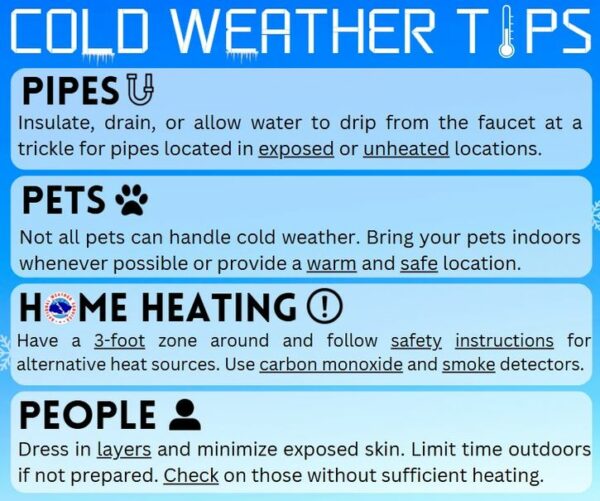
IMPACTS: As a reminder, frostbite and hypothermia will occur if unprotected skin is exposed to these temperatures. An extended period of subfreezing temperatures could cause pipes to burst. Use caution while traveling outside. Wear appropriate clothing, a hat, and gloves. Keep pets indoors as much as possible. Make frequent checks on older family, friends, and neighbors. Ensure portable heaters are used correctly. Do not use generators or grills inside. To prevent freezing and possible bursting of pipes they should be wrapped, drained, or allowed to drip slowly.
Tomorrow will be warmer, but still cold by Alabama standard, with sunshine in full supply temperatures reach the 40s and low 50s Friday afternoon.
BIRMINGHAM ALMANAC: For February 20th, the average high for Birmingham is 60° and the average low is 40°. The record high is 80° set in 2018, while the record low is 16° set in 1958. We average 0.19” of precipitation on this date and the record value is 3.02” set in 1961.
WARMING TREND: Over the weekend, the warming trend begins with highs returning to the 50s Saturday and Sunday; lows will be in the upper 20s and lower 30s. Both days will be dry and Saturday will feature plenty of sunshine, while more clouds than sun are expected on Sunday.
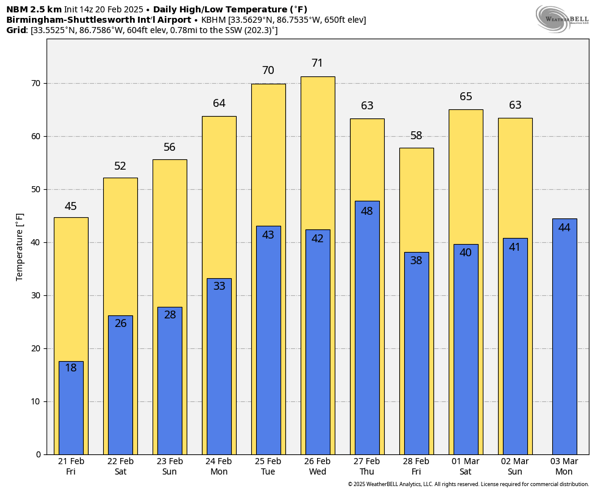
SPRING-LIKE NEXT WEEK: The warm-up continues and temperatures will be climbing well into the 60s Monday and Tuesday with widespread 70s expected by Wednesday. A cold front will bring showers Thursday, but rain amounts should be generally 1/2 inch or less and there is no threat of severe weather at this time. Cooler air flows back into the state Friday with highs near average values this time of year; upper 50s and lower 60s.
WORLD TEMPERATURE EXTREMES: Over the last 24 hours, the highest observation outside the U.S. was 107.6F at Telfer, Australia. The lowest observation was -68.4F at Vostok, Antarctica.
CONTIGUOUS TEMPERATURE EXTREMES: Over the last 24 hours, the highest observation was 89F at Brighton, FL. The lowest observation was -34F at Willow City, ND.
Category: Alabama’s Weather, ALL POSTS, Social Media


