

A chilly start to the day with widespread 40s in most locations, but under a sky full of sunshine, temperatures are surging into the upper 70s, with some low 80s showing up this afternoon. The relative dry air is place allows for the big diurnal temperatures swings of nearly 40 degrees across Alabama.
BIRMINGHAM ALMANAC: For February 26th, the average high for Birmingham is 62° and the average low is 41°. The record high is 80° set in 1977, while the record low is 13° set in 1967. We average 0.19” of precipitation on this date and the record value is 1.68” set in 1998.
ACROSS THE USA: A clipper system to bring scattered rain and snow showers from the Midwest to the Northeast through the next couple of days. Another clipper system to reach the upper Great Lakes late Thursday bringing additional snowfall. Above to well above average temperatures expected to persist for most of the country.
TOMORROW/FRIDAY: A weak cold front will bring some showers to Alabama tomorrow, but with limited moisture rain amounts will be light, in fact most locations we expect to remain dry. Good news, there is no threat of severe weather. It will be cooler tomorrow with highs in the 60s. For Friday, expect sunshine in full supply with highs in the mid to upper 60s.
HELLO MARCH: The new month starts off with incredibly pleasant weather for Alabama; sunny pleasant days and fair chilly nights. Highs will be near 70 ° Saturday, but Sunday will be cooler with highs closer to 60°; lows will be mostly in the 30s and 40s.
NEXT WEEK: Monday will feature more clouds than sun with highs in the 60s. On Tuesday, a few scattered showers are possible as a dynamic storm system takes shape to our west. Warm, southerly flow will allow temperatures to return to the low 70s.
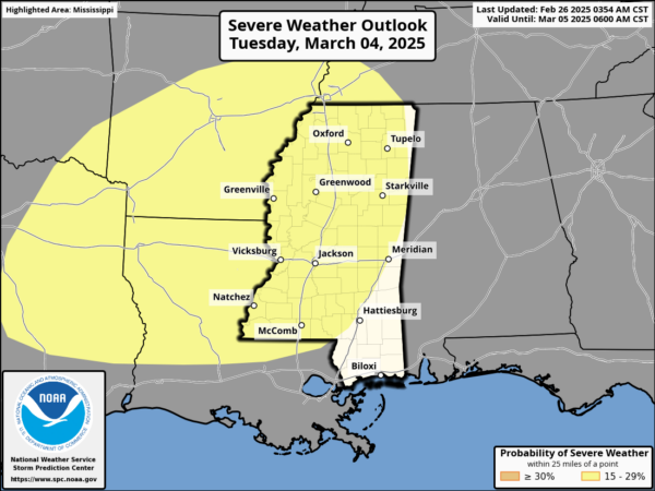
In fact, the Storm Prediction Center (SPC), has defined a risk of severe storms west of Alabama Tuesday; for now no formal risk is in place in Alabama for Tuesday of Wednesday, but this could easily change in the coming days as new model and forecast data comes in. There will be a strong wind fields and with unstable air moving north out of the Gulf of Mexico, some strong to severe storms are very possible. We will keep an eye on thing the next several days. Drier air will move into the state for the second half of the week being the storm system. High next week will be in the 60s and 70s.
WORLD TEMPERATURE EXTREMES: Over the last 24 hours, the highest observation outside the U.S. was 110.7F at Birdsville Airport, Australia. The lowest observation was -65.6F at Vostok, Antarctica.
CONTIGUOUS TEMPERATURE EXTREMES: Over the last 24 hours, the highest observation was 96F at Glamis, CA. The lowest observation was 8F at Crested Butte, CO.


