
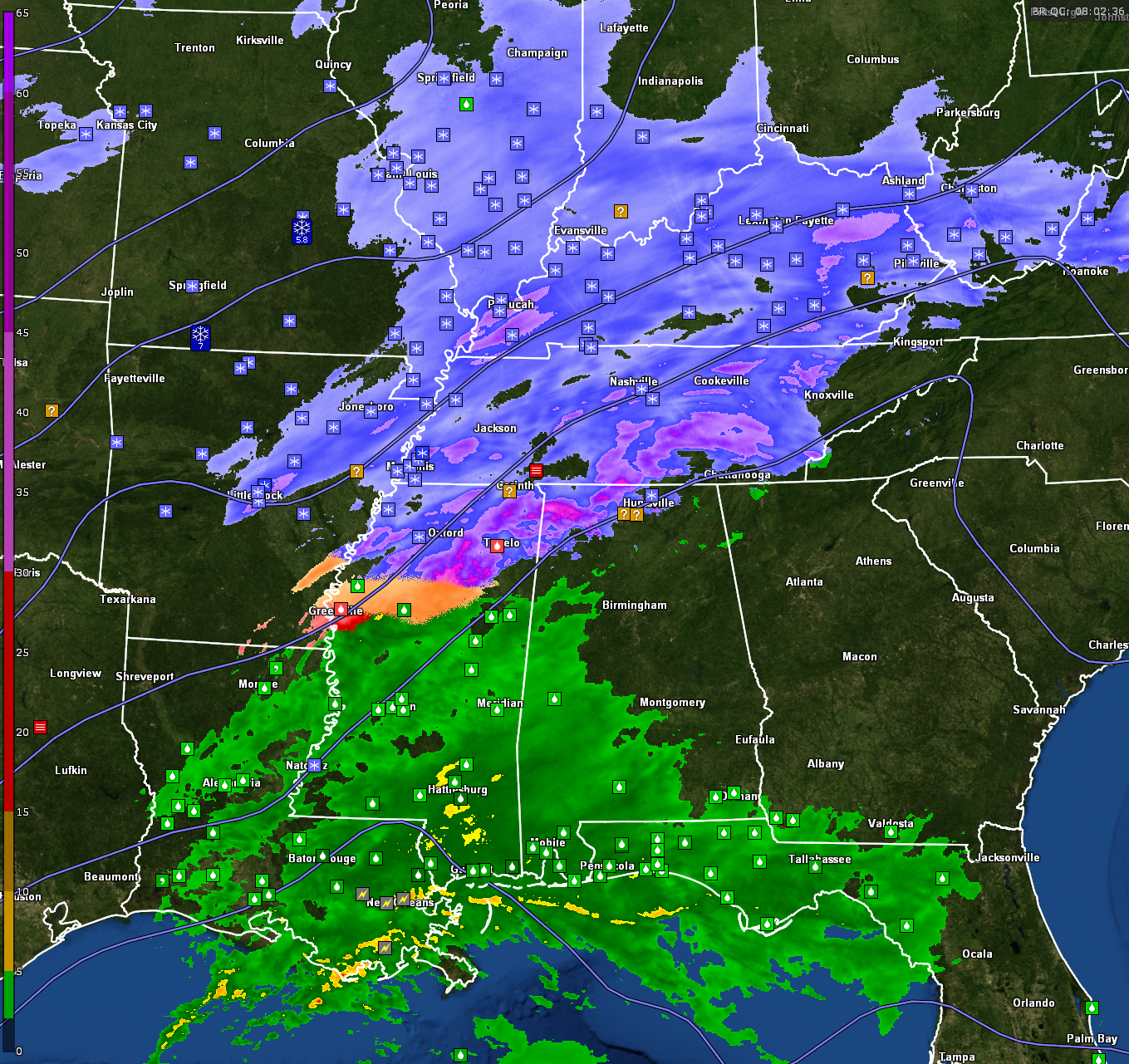
Precipitation Type on Surface Observations This Hour
LATEST ASSESSMENT:
– A “wintry mix” of snow, sleet, and freezing rain is expected overnight across northern Alabama, mainly along and north of a line from Vernon to Jasper to Oneonta to Gadsden to Centre.
– Snow accumulation of around one inch is expected in the western half of the Tennessee Valley, especially near the Shoals, with isolated heavier amounts.
– Some high-resolution models suggest localized snow totals of 2-3″ due to convergence zones and possible enhancement from the Tennessee River.
– Areas south of Tuscaloosa, Birmingham, and Anniston will see only rain, with no freezing precipitation expected.
– Freezing rain and icy conditions are likely on bridges and overpasses, causing travel impacts through the early morning hours Wednesday.
– Precipitation will end around 10 AM Wednesday, but with cloudy skies and cold temperatures barely getting above freezing, roads may remain slick and will definitely refreeze Wednesday night. Gusty winds of 20-25 mph on Wednesday will help dry surfaces, but lingering moisture may still contribute to black ice overnight as temperatures drop into the teens.
– Wind chills could reach as low as 0°F to 5°F Thursday and Friday mornings, prompting a cold weather advisory from midnight Wednesday to noon Thursday, with an extension likely into Friday.
– Dry weather will dominate the weekend, with a warming trend beginning by Sunday.
THUNDERSTORM & SEVERE WEATHER OUTLOOK:
– A marginal risk of severe thunderstorms exists across southeast Texas and southern Louisiana through the overnight hours.
– Isolated severe storms remain possible across southeast Texas, shifting across south Louisiana overnight.
– The primary hazards include hail, but a brief tornado and localized strong wind gusts may occur along the immediate Louisiana coast.
– Across southern Alabama, scattered showers and thunderstorms are expected overnight into Wednesday, with no severe weather currently anticipated.
PRECIPITATION REPORTS:
– 8.0” snow reported in East Prairie, MO (Mississippi County).
– 8.0” snow reported in Fredericktown, MO (Madison County).
– 2.0” snow reported in Paris, TN (Henry County).
– 3.8” snow reported in Union City, TN (Obion County).
SPOT REPORTS:
– Light snow in Huntsville, AL (31°F)
– Light freezing rain in Tupelo, MS (32°F)
– Light rain in Greenwood, MS (37°F)
– Blowing snow and fog in Tunica, MS (21°F)
– Light snow at Memphis International Airport (22°F)
– Snow at NAS Millington (22°F)
WATCHES, WARNINGS, AND ADVISORIES:
WINTER WEATHER ADVISORIES:
– NWS Birmingham: In effect through 9 AM Wednesday for areas along and north of Vernon to Jasper to Oneonta to Gadsden to Centre.
– NWS Huntsville: In effect through 11 AM Wednesday for northern Alabama and southern middle Tennessee.
COLD WEATHER ADVISORIES:
– NWS Birmingham: In effect from midnight Wednesday night to noon CST Thursday.
– NWS Huntsville: In effect from midnight Wednesday to noon Thursday, with likely extension into Friday.
SURROUNDING STATES UPDATE:
– Tennessee: Snow accumulation of 3-6 inches is expected across western and middle Tennessee, with isolated totals up to 7 inches near the Kentucky border. Travel conditions are hazardous, especially near Clarksville, Paris, and Union City. Cold weather advisories are in effect across the state with wind chills near or below zero.
– Mississippi: Light snow and freezing rain continue in northern parts of the state, including Tunica and Olive Branch, where blowing snow has been reported. Accumulations remain light, but roads may become hazardous.
– Central Mississippi: A Winter Weather Advisory is in effect through 7 AM Wednesday for areas including the Delta and the Golden Triangle Region. A mix of freezing rain and sleet may create hazardous conditions, primarily on bridges and overpasses. Accumulations remain light, but gusty winds will drive wind chills into the upper single digits to lower teens northwest of the Natchez Trace.
– Georgia: Light snow is expected in the higher elevations of far northern Georgia, with up to an inch possible above 2500 feet. A winter weather advisory is in effect for the northeast part of the state.
– Arkansas & Missouri: Heavy snow has been reported in eastern Arkansas and southeast Missouri, with totals between 4-8 inches. Areas around East Prairie, MO, and Fredericktown, MO, have reported 8 inches of snow with some drifting.
NATIONAL NOTES:
– Record lows could be set tomorrow morning, including Wichita, KS at -2°F and Amarillo, TX at -2°F.
– Oklahoma City is expecting a low of 2°F, which will be a record.
– Snow is expected to develop in the Plains today, with heavy snowfall anticipated in parts of eastern Kansas, southern Missouri, and the Ozarks.
CALLS TO ACTION:
– Use extreme caution when traveling on shaded or sheltered roads, which may develop black ice.
– Dress for extreme cold with layers, hats, and gloves.
– Ensure pets have warm shelter and check on vulnerable neighbors.
– Be prepared for potential power outages due to ice accumulation on power lines.