

A PDS (Particularly Dangerous Situation) Tornado Watch has been issued for several Alabama counties until 8pm. Here is the graphic from the NWS:
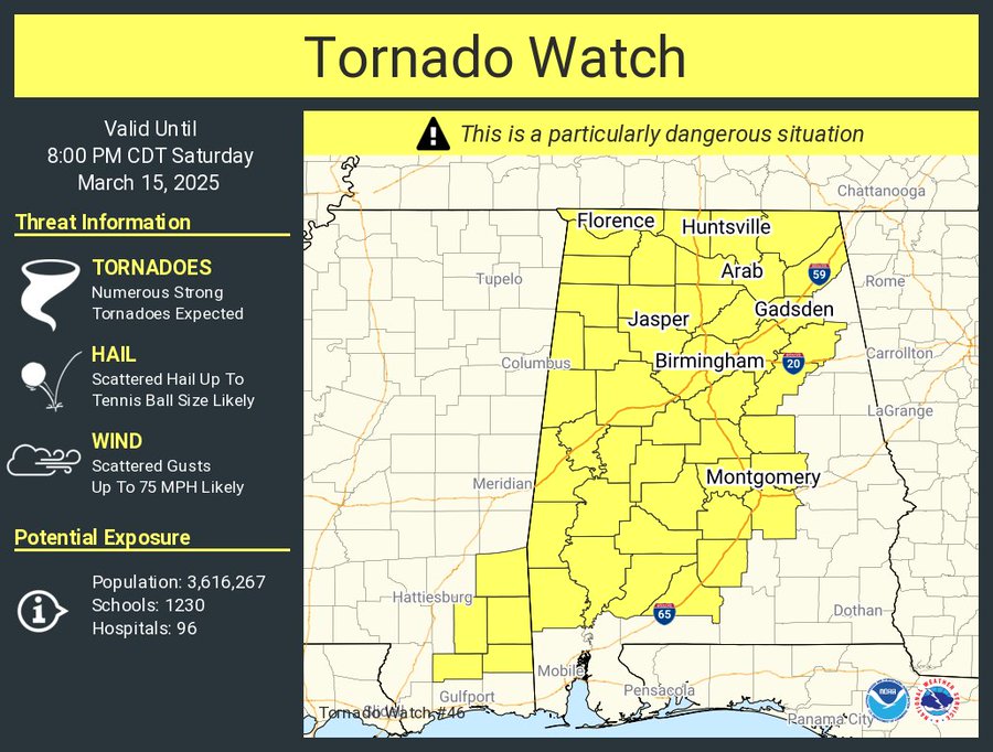
The NWS Storm Prediction Center has issued a

   * Tornado Watch for portions of
     Western, Central, and Northern Alabama
     Southeast Mississippi

   * Effective this Saturday afternoon and evening from 1225 PM
     until 800 PM CDT.

   ...THIS IS A PARTICULARLY DANGEROUS SITUATION...

   * Primary threats include...
     Numerous tornadoes and several intense tornadoes expected
     Scattered damaging winds and isolated significant gusts to 75
       mph likely
     Scattered large hail and isolated very large hail events to 2.5
       inches in diameter likely

   SUMMARY...Intense supercells capable of producing numerous tornadoes
   will spread eastward from Mississippi into Alabama this afternoon
   and evening. Given the very favorable environment, multiple intense
   to potentially violent tornadoes (EF-3/EF-4+) appear possible.
   Clusters of thunderstorms and embedded supercells will also pose a
   threat for severe/damaging winds of 60-75 mph, and large hail around
   1.5-2.5 inches in diameter.

   The tornado watch area is approximately along and 65 statute miles
   east and west of a line from 20 miles north northeast of Huntsville
   AL to 55 miles west southwest of Evergreen AL. For a complete
   depiction of the watch see the associated watch outline update
   (WOUS64 KWNS WOU6).

   PRECAUTIONARY/PREPAREDNESS ACTIONS...

   REMEMBER...A Tornado Watch means conditions are favorable for
   tornadoes and severe thunderstorms in and close to the watch
   area. Persons in these areas should be on the lookout for
   threatening weather conditions and listen for later statements
   and possible warnings.
Category: Alabama’s Weather, ALL POSTS, Severe Weather, Social Media


