
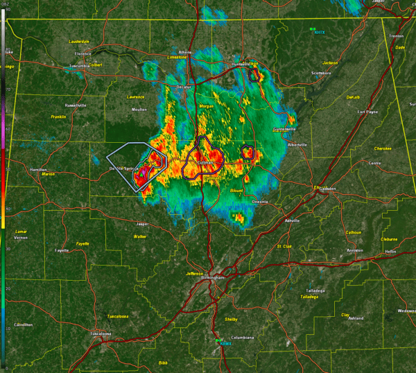
Round one of our severe weather event is now officially done, as the Storm Prediction Center has removed all severe weather risk areas for the overnight hours. While showers and a few rumbles of thunder remain possible through the early morning hours, the severe weather threat has ended—for now. Here is the current radar:

Dime sized hail was reported near Holly Pond in Cullman County just before 730 p.m.
Round one of our severe weather event is now officially done, as the Storm Prediction Center has removed all severe weather risk areas for the overnight hours. The afternoon storms on Thursday produced isolated severe weather across Alabama and Mississippi, including a few reports of hail and strong wind gusts, but the event largely remained under control due to limited instability and forcing. With that phase over, all attention now turns to the next two rounds of severe weather—Friday night into early Saturday morning, followed by what is shaping up to be a high-end severe weather outbreak during the day on Saturday into early Sunday.
The second round will unfold Friday night as a strengthening low-level jet transports deep moisture northward into Mississippi and Alabama. With strong warm-air advection, increasing instability, and ample shear, the environment will become more supportive of strong to severe storms overnight. While forcing remains somewhat uncertain, high-resolution models continue to suggest that scattered supercells could develop ahead of a more organized line of storms that will push eastward through Mississippi and into western Alabama after midnight. If these storms develop, all modes of severe weather will be possible, including large hail, damaging winds, and tornadoes—some of which could be strong. The main limiting factor is whether or not storms can overcome the lingering cap in place, but if they do, this round could turn into a significant threat, particularly for west Alabama before sunrise.
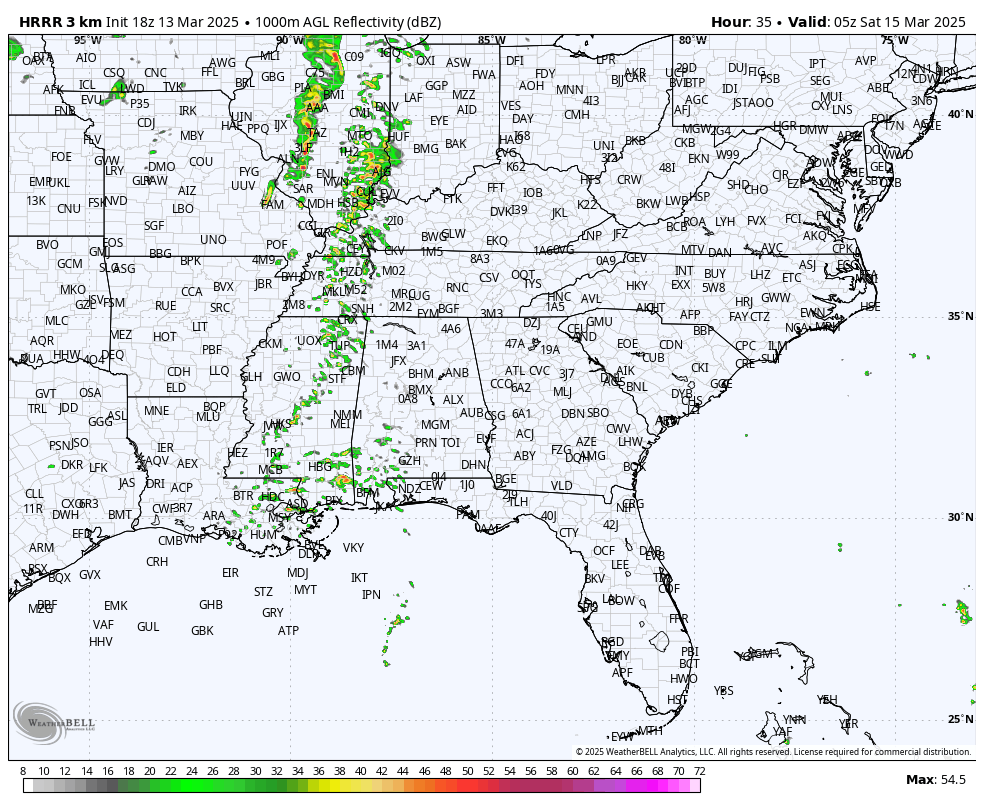
HRRR projected radar for late Friday night from 11 p.m. until Saturday morning at 11 a.m. showing potential storm development over Alabama…
Regardless of how much storm coverage develops overnight, the third and most dangerous round of severe weather will arrive Saturday afternoon into Saturday night. A deepening surface low will track from the Ark-La-Tex toward the Ohio Valley, setting up a highly unstable warm sector across the Deep South. A powerful low-level jet (60-70 knots) and upper-level support (100+ knot jet streak) will create a volatile environment capable of sustaining long-lived, rotating supercells. Forecast soundings indicate steep lapse rates, strong low-level turning, and mixed-layer CAPE values in the 1500-2000 J/kg range—perfect ingredients for intense supercells with the potential for significant tornadoes, destructive winds, and large hail.
I will come back with a look at our first peek into Saturday afternoon with our best convection allowing model, the HRRR, before bedtime tonight.
There are two main concerns for Alabama on Saturday. First, if supercells form in the open warm sector ahead of the main line, these will have the greatest potential to produce strong to violent tornadoes, with long-track potential. Given the extreme wind shear, any discrete storm will be capable of producing intense rotation and significant damage. Second, as the cold front pushes east Saturday evening into early Sunday, storms will likely merge into a powerful squall line capable of producing widespread damaging winds, embedded tornadoes, and flash flooding. Given the speed of the storms—moving at 50 to 60 mph—warnings will be brief, meaning people will need to act quickly when alerts are issued.
Beyond the severe weather threat, high winds outside of storms will also be an issue. A tightening pressure gradient will bring sustained winds of 20-30 mph, with gusts exceeding 40 mph possible. A Wind Advisory will likely be needed for much of the area.
Rainfall totals of two to four inches are expected, with localized higher amounts possible. Given the multiple rounds of storms, flooding could become a concern, especially in low-lying and urban areas.
By early Sunday morning, storms will push out of Alabama, bringing an end to the severe weather threat. However, another system could bring additional storms by midweek.
Bottom line: this is a multi-day severe weather event, with increasing intensity in each round. Round two (Friday night) and round three (Saturday) both have the potential for significant impacts, especially Saturday when a full-fledged severe weather outbreak is likely. Make sure you have multiple ways to receive warnings, a safety plan in place, and a way to act quickly when storms approach. We don’t want you to be nervous, we want you to be informed and prepared. It is serious, but it is not the end of the world folks, and nevertheless, Saturday is not a day to take lightly. Neither is tomorrow night.
More updates will follow as details continue to evolve.
We will conduct a long form live stream Saturday and Saturday night here on the AlabamaWX blog with yours truly, Scott Martin, Scott Brown, Jack Rudden, Jen Narramore and others including world class chaser Brett Adair as the event unfolds across Mississippi into Alabama.


