
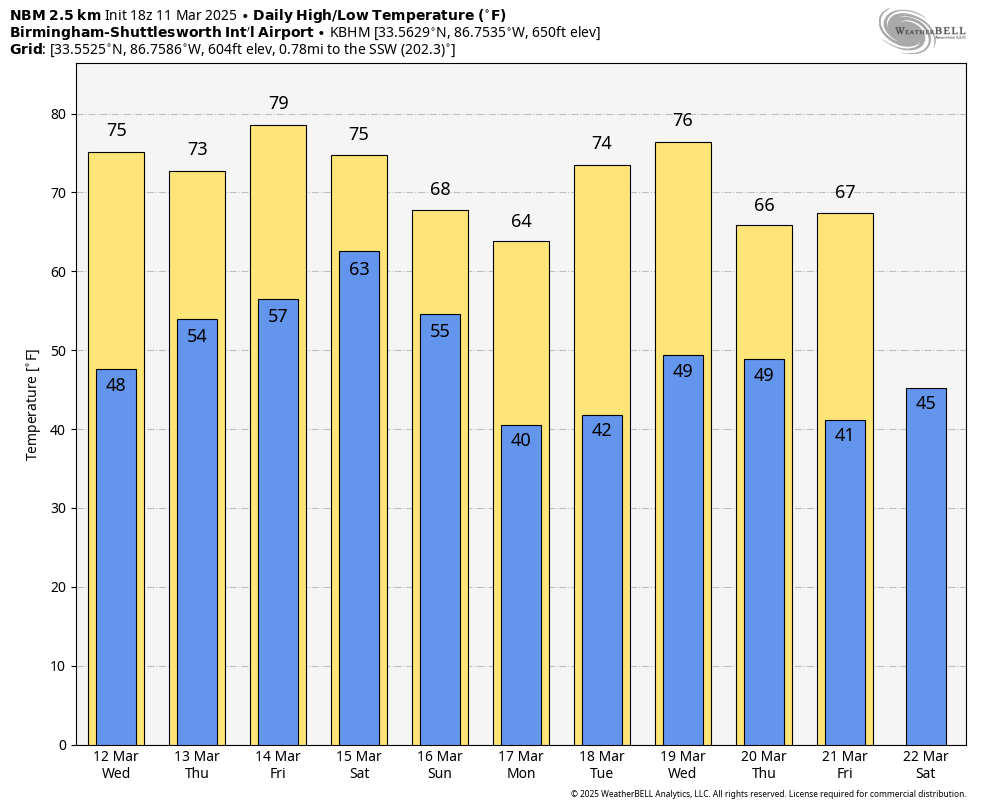
BLUE SKY: We have a cloudless sky across Alabama this afternoon with temperatures in the 70s. Tonight will be clear and cool with a low in the 46-54 degree range.
Tomorrow will be another mostly sunny, mild day with a high in the 70s. Clouds increase tomorrow night.
THURSDAY: A fast moving disturbance will bring showers and a few thunderstorms into the state Thursday. SPC has now defined a low end “marginal risk” (level 1/5) of severe thunderstorms for a good part of the state…
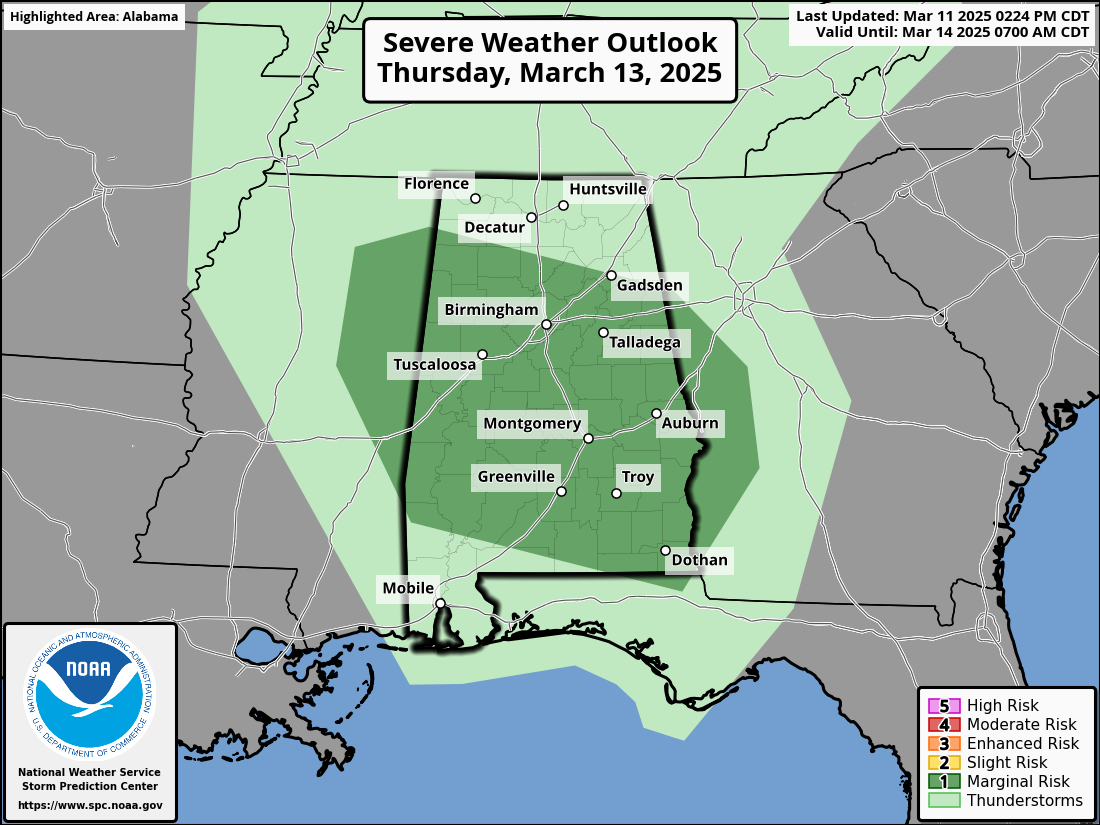
A few storms Thursday could produce gusty winds and some small hail, but the overall threat is low with weak dynamic support. The high Thursday will be in the 70-76 degree range.
Then, on Friday, the weather will be dry with a mix of sun and clouds. A few spots over the southern half of the state could reach the 80 degree mark.
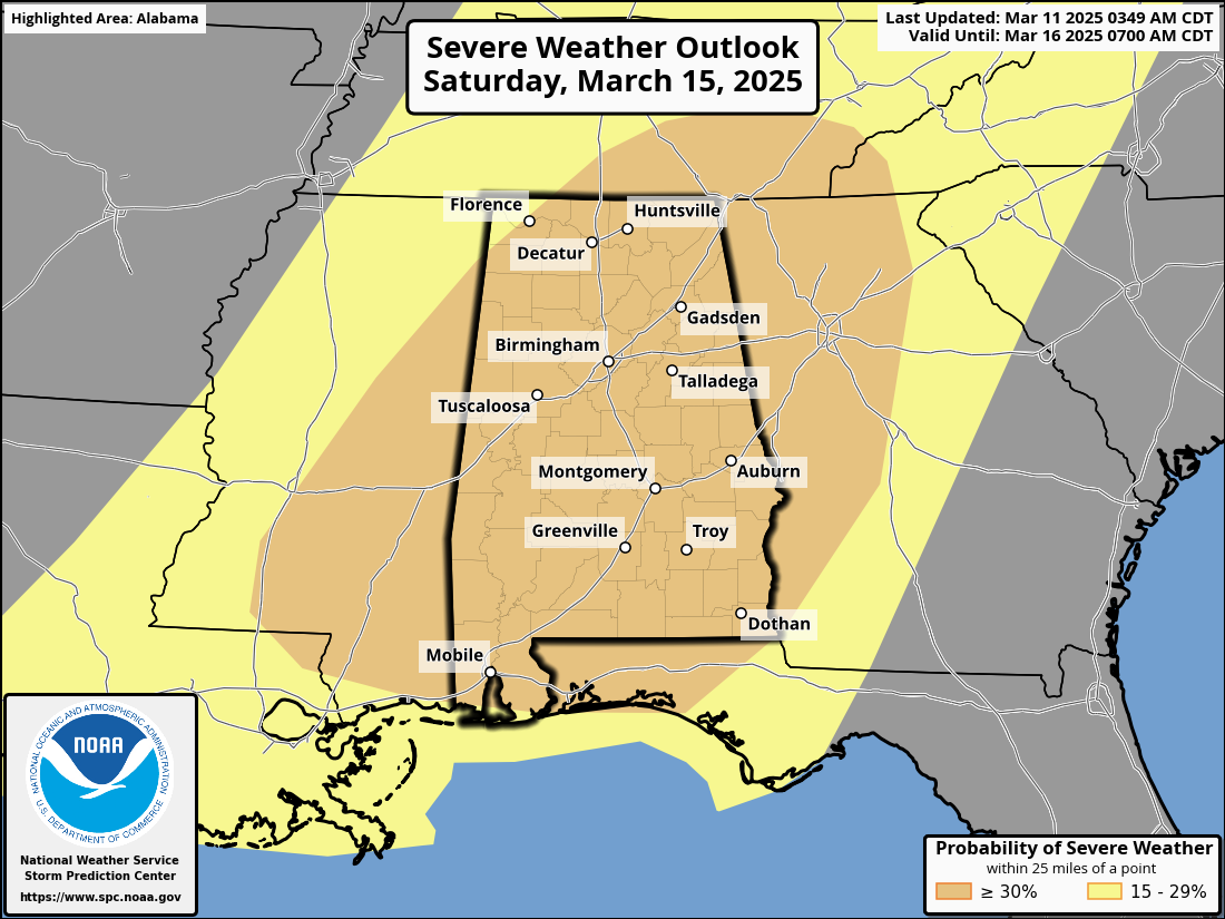
SEVERE WEATHER THREAT FRIDAY NIGHT THROUGH EARLY SUNDAY MORNING: SPC has much of Alabama in an enhanced risk of severe thunderstorms Saturday and Saturday night.
Here are the updated key messages…
*Severe storms could move into Northwest Alabama as early as Friday night, generally after 9:00 p.m. We expect multiple rounds of strong to severe storms Friday night through Sunday morning; the broad window from 9:00 p.m. Friday through 6:00 a.m. Sunday. Of course, we won’t have continuous rain during this 33 hour window… the sun might even pop out at times. But just understand a strong/severe thunderstorm is possible at any hour during this time frame.
*I know there are many outdoor events Saturday; there is no way of knowing exactly when a severe storm will move through a specific city or town at this point. Just be very weather aware Friday night through Sunday morning during the defined window.
*All modes of severe weather will be possible with the heavier storms, including large hail, damaging winds, and a few tornadoes. A strong tornado will be possible, if not likely under these conditions (EF-2 or higher by definition).
*Gradient winds (not related to thunderstorms) will gust to 30/40 mph. Not as extreme as the gradient winds we experienced with the event one week ago. The main concern will be severe storms this time.
*Rain amounts of 2-3 inches are possible, and some flooding issues could develop. Heaviest rain will be across North Alabama.
*Is this another April 27, 2011? No. That event was generational. But every severe weather threat needs to be taken seriously; all it takes is one tornado coming down your street to make it YOUR April 27. This does look like a higher end severe weather threat for Alabama.
*Have a reliable way of hearing warnings; never an outdoor siren. A NOAA Weather Radio is the baseline. Be sure WEA (Wireless Emergency Alerts) are enabled on your phone, and have the ABC 33/40 weather app installed.
*Know the safe place in your home, and in that places have helmets for everyone. If you live in a mobile home, know the location of the nearest shelter or business that is open 24/7 that can serve as a shelter. Have transportation arranged.
Once we get within 60 hours of the event we will be able to see output from high resolution, convection allowing models that will give us a much better idea of the small scale features that usually determine the magnitude of a severe weather event.
The sky begins to clear Sunday as dry air returns to the Deep South.
NEXT WEEK: The weather looks dry for the first half of the week; global models suggest a disturbance could bring showers and possibly a thunderstorm to Alabama late Wednesday and Wednesday night. See the video briefing for maps, graphics, and more details.
ON THIS DATE IN 1953: An F4 tornado cut an 18-mile path through Haskell and Knox counties in Texas. Seventeen people were killed, and an eight-block area of Knox City was leveled.
ON THIS DATE IN 1963: A tornado moved through southern and eastern Cullman County killing two and injuring six others. Some of the hardest hit communities included Berlin and Fairview.
Look for the next video briefing here by 6:00 a.m. tomorrow…


