

IMPROVING WEATHER: The sky has becoming sunny across the northern 2/3 of Alabama this afternoon as dry air returns; clouds over the southern counties will move out this evening. Tonight will be mostly clear with a low in the 40s. We might see a few spots over North Alabama in the upper 30s.
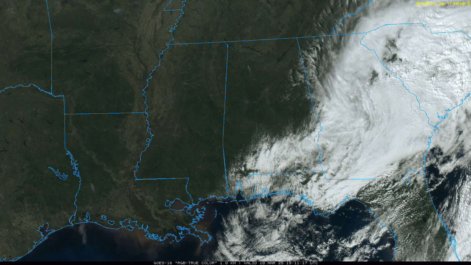
Tomorrow and Wednesday will be dry and mild with highs in the 70s. Then, a fast moving disturbance will bring showers into Alabama Thursday. A thunderstorm is also possible, but for now we are not expecting any severe storms. Rain amounts Thursday should be generally under 1/2 inch. Then, Friday looks dry and warm with a high around 80 degrees for most communities.
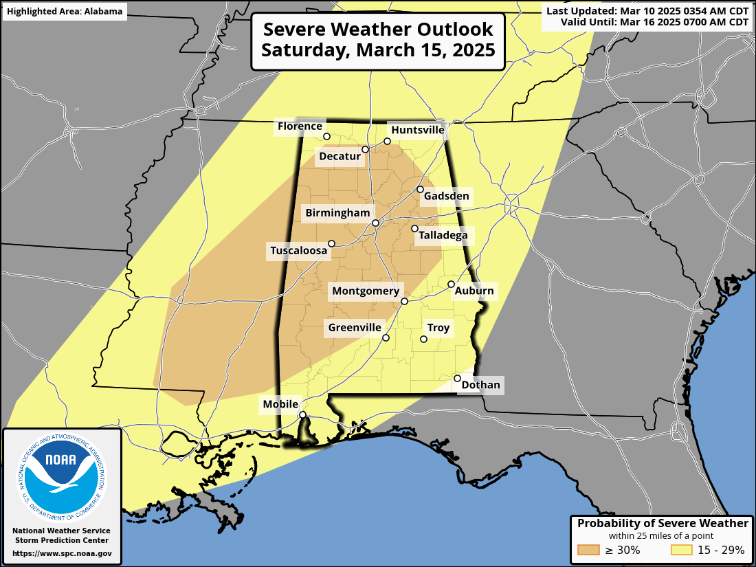
SATURDAY SEVERE THREAT: Confidence is high that a dynamic storm system will bring the threat of severe thunderstorms to the Deep South as the weekend begins. The threat actually begins Friday in a broad zone from Louisiana and Mississippi to Illinois… then shifting into Alabama Saturday and Saturday night. SPC has already defined an enhanced risk over much of Alabama Saturday.
A few notes…
*We have confidence in the synoptic scale pattern (large scale), but we won’t know the mesoscale features (small scale) until mid-week. Often the mesoscale setup will determine the magnitude of an event.
*All modes of severe weather will be possible Saturday and Saturday night, including hail, damaging straight line winds, and tornadoes.
*Gradient winds will be an issue as well (not related to thunderstorms). However, we don’t expect gradient winds to be as strong as the event we experienced last Tuesday (March 3).
*It will not rain all day Saturday, but multiple rounds of storms will be possible. We will be much more specific about timing later this week.
Understand having a severe weather threat in Alabama in March is not unusual; this is one of our more active severe weather months. Just be sure you have a reliable way of hearing warnings (never an outdoor siren!), and a good plan if you are in a tornado warning polygon.
Dry air returns Sunday; highs over the weekend will be mostly in the 70s.
The first half of the following week looks dry and mild; rain will likely return by Thursday or Friday (March 20-21). See the video briefing for maps, graphics, and more details.
TOTAL LUNAR ECLIPSE THURSDAY NIGHT: The Moon will pass into Earth’s shadow and appear to turn red late Thursday night and into the early morning hours of Friday.
In a total lunar eclipse, the entire Moon falls within the darkest part of Earth’s shadow, called the umbra. When the Moon is within the umbra, it appears red-orange. Lunar eclipses are sometimes called “Blood Moons” because of this phenomenon. You don’t need any special equipment to observe a lunar eclipse, although binoculars or a telescope will enhance the view. A dark environment away from bright lights makes for the best viewing conditions.
At Birmingham (and for most of Alabama), totality will begin at 1:26a CDT Friday March 14, ending at 2:31a CDT. We are expecting clouds and showers Thursday, but there is a chance clouds will move out by the time of the eclipse. But viewing is very “iffy” due to potential cloud cover.
ON THIS DATE IN 1986: Severe thunderstorms and tornadoes hit Indiana, Kentucky, and Ohio. A total of 19 tornadoes occurred. Three of the tornadoes in Indiana reached F3 intensity. A densely populated subdivision of Southeast Lexington, Kentucky, was heavily damaged by a tornado. Twenty people were injured, and 900 homes were destroyed or demolished. A very strong thunderstorm downburst hit the Cincinnati area. At the Greater Cincinnati Airport, windows were blown out of the control tower, injuring the six controllers on duty.
Look for the next video briefing here by 6:00 a.m. tomorrow…
Category: Alabama’s Weather, ALL POSTS, Weather Xtreme Videos


