

NO VIDEO TODAY BECAUSE OF THE EXTENDED SEVERE WEATHER COVERAGE YESTERDAY
YESTERDAY’S RECAP
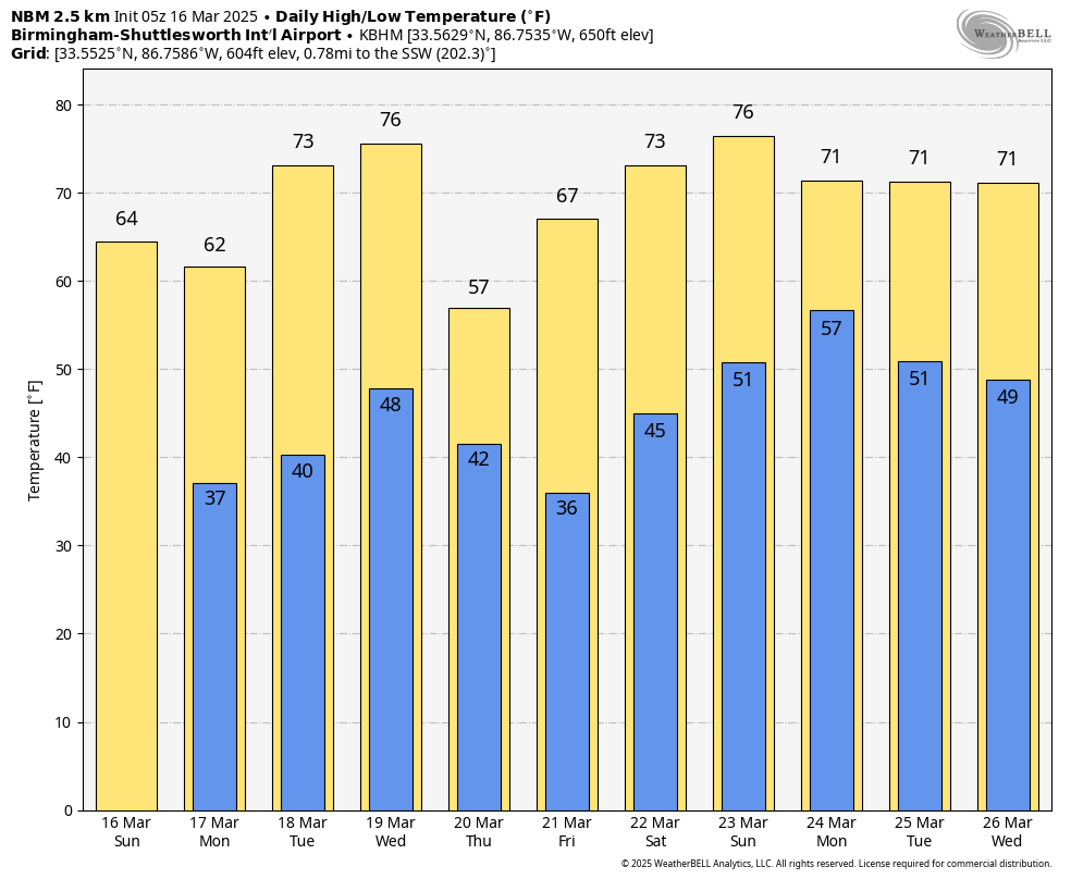
Saturday brought a mix of stormy weather and gusty winds across Alabama, as the cold front pushed through the region. Thirteen tornadoes or more may have impacted the state and there may have been three fatalities. Rain and thunderstorms cleared out by the evening, leaving behind cooler and drier conditions. Highs reached the mid-70s in southern Alabama, while areas further north saw temperatures drop more quickly with the advancing front.
SUNDAY’S WEATHER
A much calmer day is ahead as the front moves eastward, bringing sunshine and seasonably cool temperatures. Expect highs in the mid-60s across northern and central Alabama, with upper 60s to low 70s further south. A few wraparound clouds and light showers are possible in northeastern parts of the state early in the afternoon, but most areas will stay dry. Overnight lows will drop into the mid to upper 30s, with patchy frost possible in sheltered areas.
FIRST HALF OF THE WEEK
High pressure builds in on Monday, keeping the region dry with mostly sunny skies. Highs will climb back into the low to mid-60s, with overnight lows dropping into the mid-30s. By Tuesday, temperatures begin a slow warming trend, reaching the upper 60s with lows in the upper 30s to low 40s. Winds remain light out of the northwest Monday, shifting back to the south by Tuesday afternoon.
MIDWEEK RAIN CHANCES
A developing system to our west will bring increasing cloud cover Wednesday, with rain chances returning late in the day. At this time, moisture looks somewhat limited, meaning widespread severe weather is not expected. However, scattered showers and a few thunderstorms will be possible Wednesday night into Thursday. Highs will remain mild, in the upper 60s to low 70s, with overnight lows in the upper 40s to lower 50s.
LOOKING AHEAD TO NEXT WEEKEND
After the midweek system moves through, dry and cooler conditions return Friday and Saturday. Highs will remain in the 60s, with lows in the upper 30s to low 40s. Another disturbance may bring rain back to the region by late Sunday or early the following week.
BEACH FORECAST
Rip current risks remain high through Monday, with surf heights of 5 to 7 feet today and gradually decreasing to 2 to 3 feet by Tuesday. Water temperatures are in the upper 60s along the Alabama and Florida Gulf Coast. Today will be partly sunny with a chance of showers and thunderstorms and highs in the mid-70s. Winds remain breezy, shifting westward at 10-15 mph by the afternoon. Conditions improve Monday, with sunny skies and cooler temperatures in the mid-60s.
TODAY IN WEATHER HISTORY – MARCH 16, 1973
A series of tornadoes tore through central Alabama, causing significant damage. An F2 tornado near Havana in Hale County destroyed a large farm complex, while another near Cedarville demolished multiple dairy barns and took down five steel transmission towers designed to withstand 200 mph winds. In Pelham, an F2 tornado heavily damaged a shopping center and a manufactured home sales lot, injuring five. Earlier in the morning, another tornado tracked through Chilton and Coosa counties, damaging homes, barns, and timber. Additional tornadoes in Livingston and Pell City left widespread structural and tree damage.
Category: Alabama’s Weather, ALL POSTS, Social Media


