

No video this morning because of technical difficulties.
Severe storms swept out of Central Alabama early this morning, with a tornado watch in effect until 6 AM. Some storms produced damaging winds in excess of 60 mph,including widespread tree damage. Winds will remain gusty through mid-morning but should diminish by late morning as the wind advisory expires. Wrap-around low clouds will linger into the afternoon before clearing out this evening.
MUCH COLDER AIR ARRIVING TONIGHT:
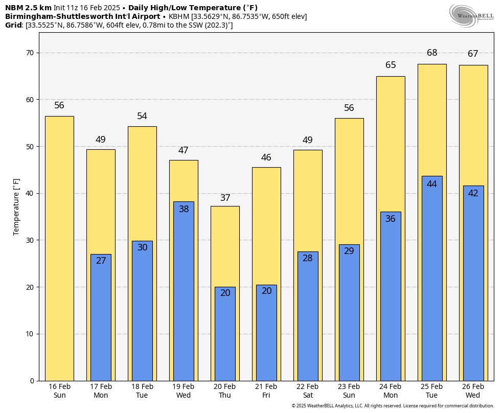
A strong cold front will push through the state today, ushering in significantly colder air. Afternoon highs will only reach the low to mid-50s, a notable drop from Saturday. By tonight, temperatures will plummet into the mid-20s across North Alabama and near 30 degrees in the southern areas. Skies will clear overnight as high pressure builds in from the Midwest.
PRESIDENTS’ DAY CHILL:
Monday, Presidents’ Day, will feature sunny skies but chilly conditions as cold air settles into the region. Morning lows will be in the 20s, and despite the sunshine, afternoon highs will only reach the upper 40s to low 50s. It will feel brisk with a light northwest breeze. Dry weather will continue into Monday night, with lows again dipping into the 20s.
MIDWEEK WINTER WEATHER THREAT:
A fast-moving system will bring a chance of rain and snow to North Alabama late Tuesday night into Wednesday morning. With overnight temperatures below freezing, areas north of I-20 could see a brief period of snow before the precipitation transitions back to rain by late morning. Accumulations should be light, but slick spots on roads are possible for the Wednesday morning commute.
WEDNESDAY COLD SNAP:
Behind the system, frigid air will surge into Alabama. Wednesday night lows will plunge into the mid to upper teens across North Alabama, the coldest temperatures so far this winter. Afternoon highs on Wednesday will struggle to reach the mid-30s north of the Tennessee River and low 40s south of I-20.
ARCTIC AIR FOR THE LATE WEEK:
Thursday and Friday will remain very cold, with highs only reaching the upper 20s to lower 30s in North Alabama and upper 30s southward. Overnight lows will drop into the mid-teens Thursday night. Sunny skies will dominate, but it will feel quite cold with wind chills in the single digits Thursday morning.
WEEKEND WARM-UP:
A gradual warming trend will set in for the weekend. Highs will return to the low to mid-40s on Friday, then climb into the upper 40s to low 50s by Saturday. Overnight lows will moderate, rising from the mid-teens Thursday night to the lower 20s Friday night. The weekend looks dry with plenty of sunshine.
LOOKING AHEAD:
No major storms are on the horizon for the weekend or early next week, but the cold pattern will persist. We’ll keep an eye on potential winter weather threats as the pattern remains active. Enjoy the sunshine on Presidents’ Day, but bundle up—winter is far from over!


