
Sunday Weather Briefing Video: From Spring-like Showers to a Wintry Whisper: Alabama’s Weather Rollercoaster : The Alabama Weather Blog

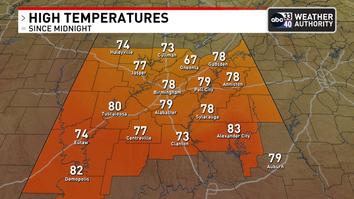
Saturday brought a taste of spring to Alabama, with unseasonably warm temperatures climbing into the upper 70s and even low 80s in some southern areas like Montgomery and Demopolis. Breezy southwesterly winds, gusting up to 25 mph at times, added to the mild feel as clouds gradually gave way to pockets of sunshine. While most areas stayed dry, a few isolated showers dotted the landscape, especially in the southeast. The warmth, combined with muggy conditions, made it feel more like early April than early February, setting the stage for the changes ahead.
TSUNAMI ALERT: A magnitude 7.6 earthquake occurred at a depth of 20 miles north of Honduras last evening. A tsunami alert was issued for the evening for parts of Puerto Rico and the Virgin Islands, but it was canceled a short time later.
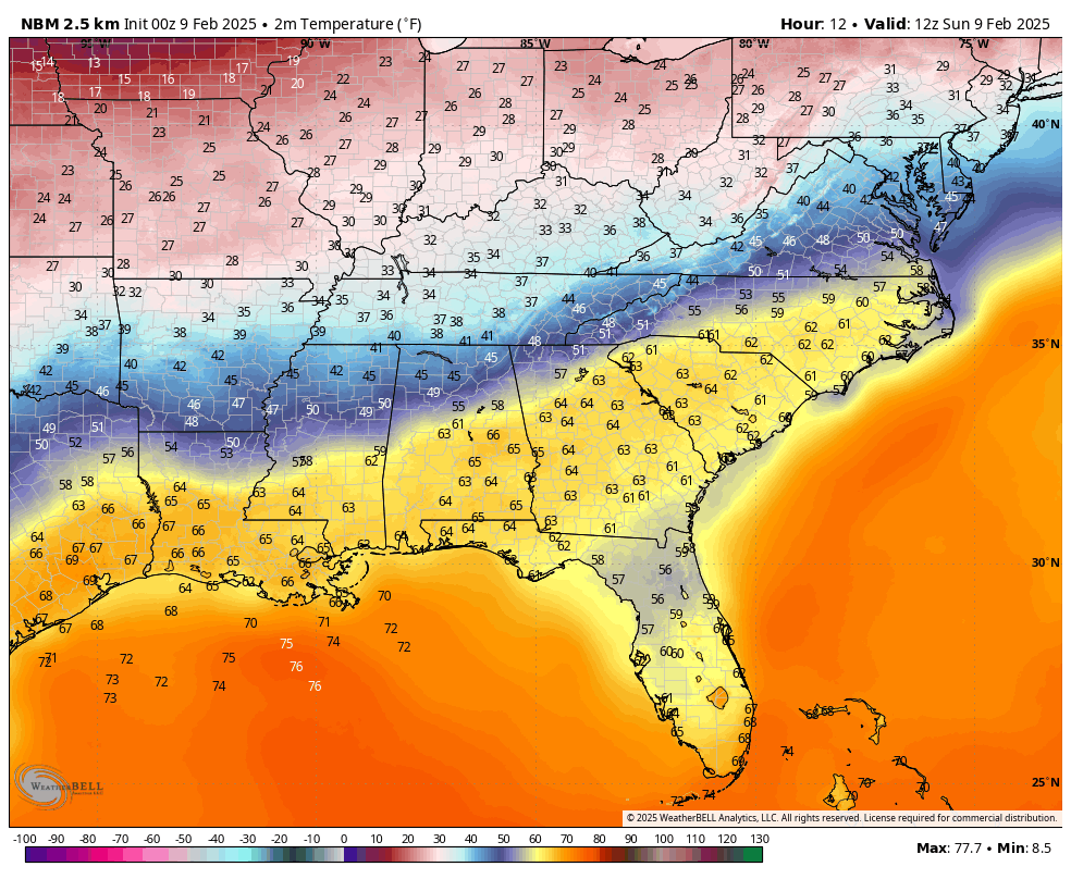
Projected 6 a.m. temperatures for this morning
HERE COMES THE COLD FRONT… A cold front is pushing south through Alabama this morning, bringing scattered showers and a noticeable temperature drop. Light rain lingers through mid-morning, but precipitation amounts will remain low, generally around a tenth of an inch or less. The real story will be the temperatures. Highs today will range widely—areas north of I-20 will struggle to reach the mid-50s, while locations south of the front will see mid to upper 60s. By the afternoon, expect mostly cloudy skies with a light northwest breeze.
A COOLER START TO THE WEEK… Monday will feature lingering cloud cover and a few scattered showers, mainly in southern Alabama, as the front remains stalled near the Gulf Coast. Temperatures will be seasonably cool, with highs in the lower 60s and overnight lows dipping into the 40s. It won’t be a washout, but off-and-on light rain will make for a damp and gray start to the new workweek.
HEAVY RAIN THREAT BUILDS… By Tuesday, deep Gulf moisture surges northward, setting the stage for widespread rain. This will be the first of several rounds of wet weather expected through Thursday. While severe storms are not expected at this time, some downpours could be heavy, leading to localized flooding concerns. Highs will remain in the 60s, with increasing humidity as warm air surges north ahead of the next system.
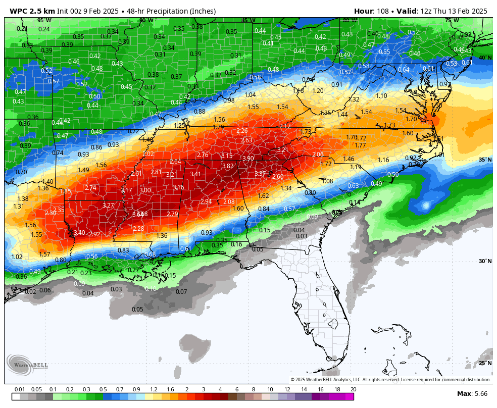
48 hour rainfall Tuesday and Wednesday
A SOGGY MIDWEEK… Rain chances remain high on Wednesday as another disturbance moves through. North Alabama will see the highest totals, with some areas picking up 2 to 4 inches of rain by this point. Flash flooding will be a concern, especially in low-lying and urban areas. Temperatures will remain mild, holding steady in the 60s, but the persistent rain will keep things feeling damp and cool.
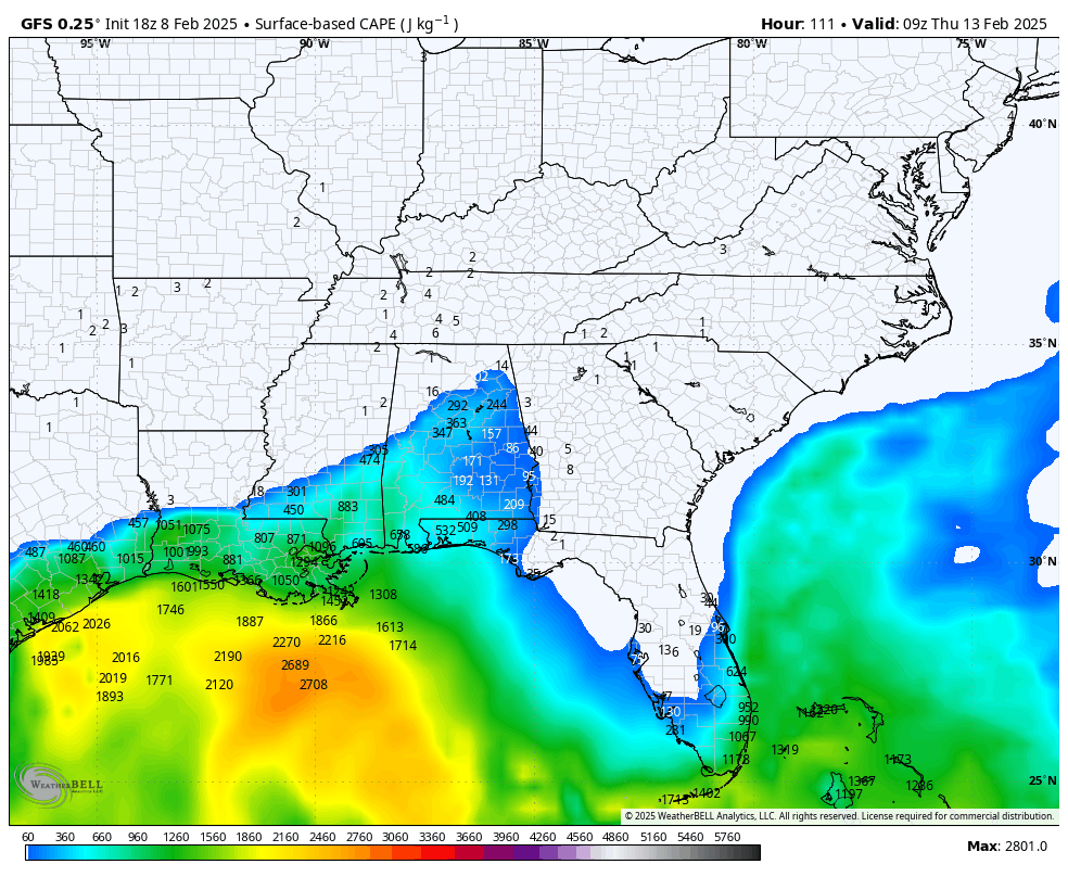
Instability early Thursday morning 3 a.m. CST
WATCHING THE SEVERE WEATHER POTENTIAL… While heavy rain is the main concern, we are closely monitoring the potential for strong storms Wednesday night into Thursday. If the warm front lifts far enough north, areas south of I-20 could see just enough instability for a few stronger storms, mainly along and south of the Gulf Coast. The overall severe weather threat remains low, but it’s something to watch as the setup evolves.
DRYING OUT TO END THE WEEK… By Friday, the rain finally moves out, and we’ll see some welcome sunshine. High pressure builds in, leading to drier and cooler conditions. Highs will be in the upper 50s to lower 60s, with overnight lows dropping into the 40s. This should bring a much-needed break from the rain, giving rivers and creeks a chance to recede after a week of heavy precipitation.
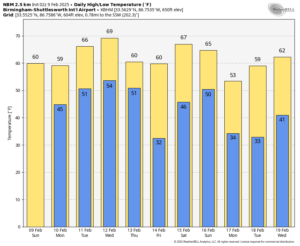
A COOLER VALENTINE’S DAY… Looking ahead to Friday, February 14, temperatures will be more seasonable. Morning lows will be in the upper 30s, with afternoon highs near 60 degrees. A few isolated showers can’t be ruled out, but overall, it should be a relatively quiet day with a mix of clouds and sun.
THE BEACH FORECAST… If you’re heading to the Gulf Coast, expect mild temperatures in the lower 70s with partly sunny skies. Water temperatures are in the lower 60s, and surf heights will be around 1 to 2 feet. The rip current risk remains low through Monday but increases to moderate levels by Tuesday and Wednesday as the onshore flow strengthens. Patchy fog will be an issue at times, especially in the mornings, so use caution if you’re out on the water early.
STILL KEEPING AN EYE ON WINTER… While our immediate forecast stays mild, there are hints of a significant pattern change beyond the seven-day period. Some models suggest a surge of Arctic air arriving around February 17th-18th, with highs struggling to get out of the 40s and overnight lows dipping into the upper 20s and low 30s. It’s too early to lock in specifics, but winter may not be finished just yet!
DANCING WITH THE STATS: The high of 82F at Dannelly Field in Montgomery established a new record high for the date. The old record of 81F was set in 1957.
WEATHERBRAINS: On this week’s show, we will talk to extraordinary tornado researcher Karen Kosiba. Watch the show live Monday night on the WeatherBrains YouTube channel at www.youtube.com/weatherbrains on on the James Spann 24×7 live channel which can be accessed on the subcarrier. The audio podcast will drop late Monday night. Check out the show’s website at www.WeatherBrains.com.
ON THIS DATE IN 2024: Prior to 2024, Wisconsin had never experienced a tornado in the month of February. However, on the evening of February 8th, 2024, an unusual and significant setup for severe weather materialized across southern Wisconsin. A dynamic low pressure system traversed northeastward across the Upper Mississippi Valley, while the warm sector expanded across the state. Afternoon sunshine facilitated the development of surface-based instability, reaching around 500 J/kg. Alongside this increasing instability, the system brought forth a combination of deep-layer and low-level shear, setting the stage for potentially rotating storms capable of producing various severe weather hazards, particularly large hail and tornadoes.
Prior to this event, there had been zero tornado warnings issued in Wisconsin during the month of February since 1986. However, during this event, the National Weather Service (NWS) office in Milwaukee/Sullivan issued a total of 5 tornado warnings. Additionally, there had been a total of 17 severe thunderstorm warnings issued in Wisconsin during February (9 in 1999, 4 in 2008, and 3 in 2017), yet during this specific event, the NWS Milwaukee/Sullivan issued 8 severe thunderstorm warnings, underscoring the exceptional nature of the severe weather outbreak on February 8th, 2024.
Category: Alabama’s Weather, ALL POSTS, Social Media


