


We’re entering the final days of March, and spring is flexing its muscles in dramatic fashion. With trees leafing out and pollen coating every car, it’s a classic Southern transition—where gorgeous blue sky days can quickly transition to severe weather events. And that’s exactly what we’ll be watching as a potent system takes aim at Alabama beginning late Sunday and continuing into Monday.
SEVERE WEATHER OUTLOOK
The Storm Prediction Center maintains an Enhanced Risk (Level 3 of 5) for a broad area from East Texas through the Ohio and Tennessee Valleys today and Monday. This enhanced risk includes northwestern Alabama during the early morning hours. In Alabama, a Slight Risk (Level 2) is in place from northwest Alabama eastward to the I-65 corridor, with a Marginal Risk (Level 1) extending into the eastern counties. Main threats include damaging winds, large hail, and a few tornadoes. Uncertainty in storm timing and mode remains high, but confidence is also high that some form of severe weather will affect Alabama late tonight into Monday.
OVERVIEW
A round of strong to severe thunderstorms is expected late Sunday night into Monday morning across Alabama, with the primary threats being damaging wind gusts and large hail. While the overall forecast timing has slowed slightly, storms are still expected to enter northwest Alabama during the early morning hours Monday—likely after 2 AM—and progress eastward through midday. Storms may evolve into a line of thunderstorms (an MCS) with embedded circulations capable of producing brief tornadoes. The most intense activity appears likely northwest of the I-65 corridor, where instability and low-level shear will overlap most favorably. Forecast soundings continue to show MUCAPE values of 1500–2500 J/kg and mid-level lapse rates steep enough to support severe hail. While confidence in some severe weather is medium to high, the exact timing, mode, and intensity of storms will hinge on evolving mesoscale features like a possible pre-frontal trough or developing meso-low. Either way, residents across Central Alabama should stay weather-aware overnight Sunday and early Monday.
DYNAMIC SETUP ALOFT
A robust mid-level trough is carving out across the Plains and beginning to tilt negative, signaling a more vigorous evolution of the system. Low-level shear, while not extreme, will be sufficient to organize storms and perhaps support isolated tornadoes—especially in northwest Alabama late Sunday night. A potent 90+ knot mid-level jet over Illinois will aid large-scale ascent and enhance storm structure.
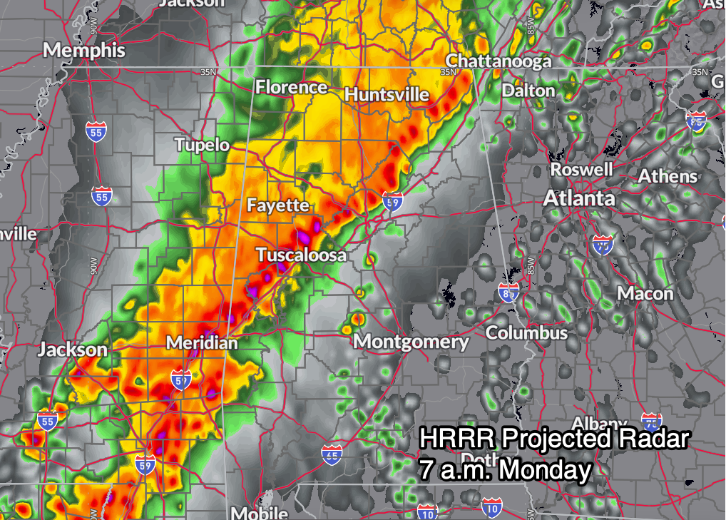
STORMS ARRIVE SUNDAY NIGHT
Much of Sunday will be warm and breezy with highs in the upper 70s to low 80s. Showers and a few storms may form in the afternoon, but the primary severe weather event is expected to arrive Sunday night into Monday morning. Storms are forecast to organize into an MCS (mesoscale convective system) over Mississippi and Arkansas and then sweep into northwest Alabama between midnight and 2 AM. These storms will likely be capable of producing damaging winds, hail, and perhaps a few tornadoes. The greatest risk will be west of I-65, though storms could remain strong as far east as the U.S. 280 corridor into late Monday morning.
THE WEEK AHEAD
Behind Monday’s storm system, a brief window of quiet, cooler weather arrives Tuesday before southwesterly upper-level flow reestablishes itself midweek. This will usher in an unseasonably warm and humid stretch across the Southeast. Temperatures will soar into the 80s by Wednesday and Thursday, and some locations may flirt with record highs. One wild card is a strong mid-latitude cyclone moving across the Upper Midwest on Wednesday, which may send a cold front toward Alabama. If that boundary sags far enough south—and if instability builds in ahead of it—there is a conditional threat for strong to severe storms Wednesday afternoon and evening across northwest Central Alabama. While confidence remains low at this time, the potential exists for all modes of severe weather if ingredients align. Otherwise, the rest of the week looks warm and muggy with low-end storm chances and plenty of Gulf moisture in place.
WEEKEND & BEYOND
The upcoming weekend looks warm and springlike, with highs in the 70s and perhaps low 80s and a chance of showers returning late Saturday into Sunday. Looking into “voodoo territory” (the week two period), models suggest a more zonal pattern with continued above-average temperatures and periodic storm systems, but no signs of a major cold snap.
DANCIN’ WITH THE STATS
As March 2025 winds down, Birmingham has experienced a warmer-than-average month, with temperatures averaging 57.4°F—1.7 degrees above normal—and a high of 81°F recorded on the 28th. The month began on a cool note, with lows dipping to 29°F on the 21st, but the second half brought several springlike days in the 70s and 80s. Despite a few rainy spells, precipitation has underperformed so far, with only 3.86 inches falling—1.29 inches below the monthly norm—and the year-to-date total of 9.84 inches is more than 5 inches below average. But we still have time to make it up,, with the official forecast calling for 1.63 inches between now and Monday night, which would put us right at normal for the month. No snow fell in March, leaving the season’s total at 2.0 inches, slightly above normal, which is 0.5 inches, thanks to a little snow in March 1993. Thunder has been right on track for the month, and March 4 featured a wind gust of 55 mph, the highest of the month. Energy usage has followed the warmth, with heating degree days running 53 below average and early cooling degree days starting to appear, signaling the inevitable arrival of the warm season.
BEACH FORECAST FOR ALABAMA AND NORTHWEST FLORIDA
A High Rip Current Risk continues for all Gulf beaches through Sunday evening, with surf heights running 3 to 6 feet. Southeast winds around 15–20 mph will keep the surf choppy. Water temperatures are in the upper 60s along the Alabama and Florida Panhandle coasts. Showers and a few thunderstorms are possible through Sunday night, but more sunshine returns by Tuesday. Please heed flag warnings and stay out of the water during red or double-red flag conditions.
WEATHERBRAINS PREVIEW
This week on WeatherBrains, we welcome Carly Anna, a YouTuber who focuses on weather histroy, a subject that is near and dear to my heart. Join us live on Monday night at 7 PM CDT at [youtube.com/weatherbrains](https://youtube.com/weatherbrains), or catch the replay anytime at [weatherbrains.com](https://weatherbrains.com) or on your favorite podcast platform.
WEATHER HISTORY: MARCH 30, 1962
It was a beautiful early spring morning in Birmingham, with azaleas and wisteria blooming and a forecast calling for a cold front with showers. That afternoon, strong storms brought widespread hail and damaging winds to North and Central Alabama. Marble-sized hail accumulated to a depth of 2 inches in Albertville, and dozens of planes were damaged at the Birmingham airport, with one flipped upside down. Damage at the airport alone topped $500,000.


