
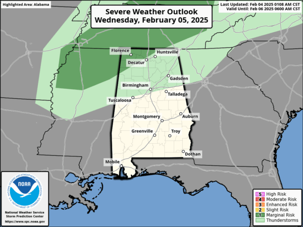
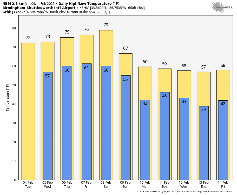
CLOSE TO RECORD WARMTH: Highs will remain in the 70s across much of Alabama through the rest of the week; some South Alabama communities could see low 80s by Thursday or Friday. Most of the state will stay dry today, but we will bring in a chance of scattered showers tomorrow, mainly over the northern counties. We SPC has actually defined a low end “marginal risk” of severe thunderstorms for the northwest corner of the state tomorrow afternoon…

While some surface based instability is available, wind fields are weak and the overall threat is low.
A few isolated showers are possible Thursday and Friday over the northern half of Alabama, but most places will stay dry.
THE ALABAMA WEEKEND: Look for a high Saturday in the 77-83 degree range across Alabama with a partly sunny sky. Then, on Sunday, cooler air begins to creep into the state with a chance of showers. The high Sunday will be in the 60s over the northern counties, with 70s for South Alabama. Rain amounts Sunday will be light.
NEXT WEEK: The week will be cooler, but still no sign of any “Arctic blast” for the Deep South. Highs will be in the 50s and 60s, with lows in the 30s and 40s. Very seasonal for mid-February. Global models suggest a good rain event is likely for Alabama by mid-week Tuesday night and Wednesday. See the video briefing for maps, graphics, and more details.
ON THIS DATE IN 1924: A tornado tore through the Rocky Ridge community (now part of Hoover) in far southern Jefferson County; three were died in the storm… all in the same family.
ON THIS DATE IN 1995: A massive nor’easter pounded areas from the southern Mid-Atlantic to northern New England. It would be the only significant storm in the 94-95 winter season. Over 20 inches of snow buried parts of upstate New York. Wind chills dropped as cold as 40 degrees below zero. Behind the storm, arctic air crossing the relatively warm waters of the Great Lakes produced intense lake effect squalls for nearly two weeks from the 4th through the 14th. Snowfall totals for the storm ranged from near two to seven feet.
Look for the next video briefing here by 3:00 this afternoon… enjoy the day!


