
As part of my year of travel where I spent a year with my husband moving from place to place every month in search of where to live, we ended up in Switzerland. We’d found the most beautiful chalet with an incredible view above the town of Sion in the Valais canton of Switzerland. I was excited for a month of beautiful alpine hikes, lakes and mountain views and boy did hiking in Valais live up to my expectations.
Hiking in Valais is incredible. You’ve got so many areas and hikes to choose from. There are valleys upon valleys, and famous towns such as Zermatt, and as long as you’re outside of those famous areas, the trails are actually pretty quiet.
I did a mixture of more and lesser-known trails and below I’m sharing my favourites. They’re what I consider to be the best hikes in Valais. From a hike up to the Matterhorn where you can enjoy a restaurant lunch with an incredible view of the famous Toblerone mountain, to surprisingly blue lakes, trails through alpine meadows filled with the sound of cowbells, and impressive glaciers at the Aletsch Arena.
If you’re visiting the Canton du Valais in Switzerland and want to go hiking, here are my recommendations for you. You can find all these routes on AllTrails (unless I’ve said otherwise) which is what I use when hiking to find routes and make sure I’m on the right track when I’m out.
AllTrails is my go-to hiking app for finding, planning, and navigating while I’m out on the trails. With offline maps on AllTrails+ you can be confident you’re still on the right track, even without mobile signal.
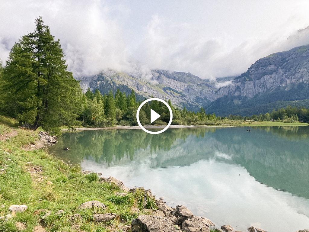
Lac de Cleuson


One of my favourite solo hikes from our month in the Valais area of Switzerland was to Lac de Cleuson. I got up early and headed out to Siviez, a smaller ski resort area or hiking area in the summer.
Parking at the end of the road by the ski lifts, I headed up along a road all the way to the lake. There wasn’t much shade on the rail, so I’m glad I started early and I’d recommend you do too if you’re visiting in the summer.
Once up at the lake, it seemed a shame to hike straight back down, so I ran/hiked around the lake taking in the beautiful turquoise colour from all perspectives.
Towards the far end of the lake (south), there’s a pretty waterfall, and then as you come back round on the western side near where you started the lake loop you’ll find Chappelle Saint Barthélemy.
I took a different route back down to the car park, following a trail through the grassy hillside, down into the trees and past a load of cows. There’s just something about the sound of cowbells in the Swiss Alps that’s so magical!
Hörnli Hut Hike in Zermatt


- 8.4 km, return
- 674 m elevation gain
My husband joined me for this one and, since he’s not as keen on hiking, we decided to buy a lift pass which would get us to the top of the Schwarzsee lift. This skips a lot of elevation gain (though there’s still quite a bit more to come), and will ensure you have some fresher legs while soaking in the views over the mountains surrounding Zermatt.
You get views of the Matterhorn very early on (since you can see it from the village of Zermatt), but the views get better and better as you hike this trail.
Starting from the lift you’ll follow signs towards the Hörnli Refuge and you’ll see plenty of other people going the same way.
Pretty early on there are some scarier sections including very narrow trails where the trail is disappearing, some scramble sections and areas where you’ll want to use the chains provided.
While this won’t be an issue for experienced hikers with scrambling experience, beginner hikers may want to choose another hike or be very confident.
I also highly recommend wearing shoes with good traction (trail runners or proper hiking boots). We saw multiple people get ankle injuries on this hike!
Once you come out to the refuge it’s time for a well-deserved lunch or drink and a snack! The refuge has plenty of food options on offer as well as drinks and you can sit outside on the terrace, or inside with amazing views of the Matterhorn. If you look closely you’ll likely see climbers making their way up the mountain. There’s also one more hut further up the peak.
You can stay at the hut if you’ve booked in advance too. It’s where many climbers stay before heading out on their multi-day mission to summit one of the highest mountains in Europe at 4,478 metres high.
We hiked back down the same way to the Schwarzsee lift but, if you’d bought a more expensive lift pass with access to more rides, you could then head off to another area of Zermatt.
Prabé Hut (Mayens de la Zour – Chalet du Prabé)


- 7.6 km return
- 650 m elevation gain
This hike was on a mountain right above our Airbnb chalet and it was so good I ended up doing it twice. Once early in the morning and the second time closer to sunset with my husband.
The first time I started right from our Airbnb, but you can also find some parking here.
From here you’ll head up through the trees for a while on a relatively steep trail. Eventually, you’ll come out to some narrow trails cutting across a steep hillside. Take your time as you won’t want to slip! As you come towards the end there are a few alternatives where you can do a small scramble up over some rocks and take a more direct (but steeper) route to the Prabé hut, or a route through the trees.
Going through the trees means you’re more wowed by the final view and it feels a little bit safer, especially if you have any fear of heights.
You’ll come out to the small hut that has some basic cooking facilities and room to sleep. No reservations are required as far as I’m aware, but there were people there both times I visited so it’s likely popular. If you plan to sleep there I’d say go earlier in the day, or bring a tent as a spare shelter.
You can also walk up above the chalet by following the trail until you reach a large cross. The view from up here to Sion and the mountains on the other side is SO good!
Tour of the Derborence Valley


Again I solo hiked this trail one morning and was so impressed. The drive out to this one can be a bit sketchy if you’re not used to European mountain driving. The roads are very narrow and you’ll likely see some buses or trucks coming in the opposite direction. Just don’t drive too fast and stay aware!
I parked up around here near a bus stop. This worked well since it’s right on the trail if you’re headed clockwise around it.
From here, follow the trail markers and keep going in a clockwise loop until you’re back where you started
There were some areas where the trail wasn’t in the best condition and you’ll have to cross over some rivers a couple of times towards the western tip. You’ll also pass through some fields which were almost unbelievably green during my trip, more cows (of course!), and some cute little farmhouse chalets.
I did this hike clockwise so that Lac Derborence was the last point on the hike. You could also just hike straight to the lake, but where’s the fun in that?!
Bisse du Ro


The Valais region of Switzerland has a lot of trails called Bisse. They’re centuries-old irrigation and water systems that have been used by people who have lived in the area. Nowadays some of them have been redone and made into hiking trails.
Bisse du Ro was the second Bisse we hiked and is a popular one to do. It’s more of a touristy one as they’ve added more safety barriers (which trust me you’d want!), and some benches in places. However, if you’re scared of heights I wouldn’t recommend it as the path is very narrow.
You can park at the parking lot in Crans-Montana which is well signposted and start following the out and back trail from there.
You can either turn back when you feel like it or continue hiking out to Lac de Tseuzier (below).
Lac de Tseuzier


We drove out to the lake in a thunderstorm and then had to wait a little while in the car before getting out to hike but it was well worth it.
This lake is another incredibly blue-green coloured lake in the Valais and I’d highly recommend it.
You’ll walk a short uphill trail to come out to the lake and the dam and then there’s a trail which goes the whole way around it.
This trail is so beautiful, especially at sunset! There are a couple of waterfalls along the way and then at the northern end of the lake, there’s a beautiful valley.
You’ll also find a swing which makes for a fun photo opportunity!
We came in the evening, but if you were here during the day you could enjoy a snack partway round at Étape de Lourantze, before continuing back to the car.
Bisse Torrent Neuf


This was the first hike we did after the long drive from the UK to Switzerland as it was super easy to get to from our Airbnb and had been recommended by our host.
From the parking lot for this Bisse, it’s a well-marked trail that’s easy to follow. Again, if you’re scared of heights I wouldn’t recommend this. Some of the trail is very narrow and there are a couple of very long suspension bridges that you likely won’t enjoy.
Besides the amazing views, one of the highlights of this trail for me was that there was some information about the history of the Bisse. It’s incredible to learn more about how people used to navigate these mountains! Plus, at the end of the bisse, there’s a restaurant and cafe where you can get some charcuterie, snacks or a drink.
We quickly came to learn that one of the best things about hiking in Switzerland is that there’s always a restaurant or cafe not too far away!
To the edge of the glacier at the Aletsch Arena


The Aletsch Arena is home to the Aletsch Glacier, one of Europe’s largest at 20 km long, though rapidly shrinking. This glacier is still seriously impressive though and well worth visiting during your stay in Valais.
We headed to the Eggishorn area which is 2869m above sea level. There are four areas and this is the highest of the four. You’ll need to buy a pass from Fiescheralp to get up the lift to the top, as there’s no public road up there.
Once at the top, it’s easy to get some incredible views of the glacier.
Wanting to soak it all in a bit more, we decided to do a hike and headed from the main viewpoint area, eastwards to Märjelensee, stopped for a blueberry tart and a drink, and then headed downhill some more to get right up close to the glacier.
Do not try and climb in or under the glacier! The water is moving incredibly fast and it’s also very cold. One slip (on the wet rocks or ice) could be disastrous.
After sitting a way back from the glacier and enjoying the view and marvelling at how impressive glaciers are (I love them!), we headed back up to Märjelensee. From here, we headed through a long tunnel which meant we didn’t have to walk back uphill. We popped out on the other side of the hill with the Eggishorn viewpoint and then followed the trails back to the village.


Last Updated on December 27, 2024 by Hannah

Hannah started That Adventurer after graduating back in 2013 and has documented all of her adventures since then. From backpacking South America to city breaks in Europe, a 3 month road trip across the USA in a self-converted van and 6 years living in Canada, you’ll find posts on all of this.
Hannah specialises in active travel and on That Adventurer you’ll find hiking, walking, biking, skiing and all sorts of active travel guides to allow you to see a destination in an adventurous way.
Now back in Europe, you’ll find new guides as Hannah and her husband spend the next year ‘digital nomading’ from Norway to Portugal, Switzerland to Scotland and places in between.


