

Sedona is an otherworldly red rock playground for hiking, full of epic trails with sweeping panoramic vistas for all skill levels. From exploring stunning caves to rock scrambling summits and Instagram-worthy sites—you cannot miss these amazing hikes in Sedona.
Three days in Sedona is enough time to hike some of the best trails, but once you get a taste of this hiking paradise, you will want to stay longer. There are so many trails to enjoy, some more than once, and you will find them all listed here!
My guide to the best hikes in Sedona has everything you need to know, including required passes, parking restrictions, detailed trail information, and tips.
Do You Need a Permit or Pass to Hike in Sedona?
Yes, you will need a pass if you park your vehicle to hike some of the best trails in Sedona because most are located within the Coconino National Forest. The Coconino National Forest surrounds Sedona and has a diverse landscape of deserts, ponderosa pine forests, flatlands, mesas, alpine tundra, and ancient volcanic peaks.
A few popular hikes in Coconino National Forest include Bell Rock, Boynton (Subway Cave), Cathedral Rock, and Doe Mountain. You will need a Red Rock Pass to park at these trailheads. If you have an America the Beautiful Pass, it will work in place of the Red Rock Pass.
You can purchase a daily, weekly, or annual pass. The weekly Red Rock Pass is best if you are going to hike for at least three days in Sedona. You can purchase the pass online or in person at the Sedona Chamber of Commerce Visitor Center.
Best Way to Get to Trailheads

Knowing key details about the trailheads is important when planning your hikes in Sedona. Most trailheads offer limited parking, with only 10 to 14 spaces. Fortunately, a free Sedona Shuttle service provides transportation to a few popular trailheads, making access easier.
The Sedona Shuttle offers several advantages. It’s eco-friendly, helps reduce traffic, and operates year-round from Thursday to Sunday, between 7 a.m. and 5:30 p.m.
The Sedona Shuttle services four trailheads: Cathedral Rock, Little Horse (Bell Rock), Soldier Pass, and Dry Creek Vista/Mescal (Devil’s Bridge). When the Shuttle operates, the parking lots to these trailheads are closed.
While the Sedona Shuttle is a convenient and sustainable option, it can limit your ability to hike some trails at sunrise and sunset, often the best times to experience Sedona’s beauty. I recommend arriving at least 30 minutes before sunrise to ensure you get a parking spot. This not only (almost) guarantees parking but also offers the opportunity to enjoy serene sunrise views while avoiding the crowds and heat of midday.
Plan a trip to Sedona Monday through Wednesday to make the most of your trip. This gives you two days to hike at any time without shuttle restrictions, specifically for sunset. If you plan to hike any trails on the Sedona Shuttle route between Thursday and Sunday, I would hike at sunrise to ensure you can park at the trailhead.
Best Hikes in Sedona
Sedona’s towering red rock formations are stunning from every angle, but stepping onto one of its trails and immersing yourself in the terrain reveals a new level of beauty and appreciation. Here are the best trails in Sedona that you cannot miss—and you could probably do them all in 4 days.
Each hike listed below reveals an estimated duration, hiking difficulty, Red Rock Pass requirement, and if the Sedona Shuttle is offered. Please remember to leave no trace, stay safe, and have a great hike!
Airport View (Mesa Summit) Trail
1.4 miles Out-and-Back | 40 minutes | Easy to Moderate

The Airport Mesa Summit is one of the best places to watch the sunset in Sedona. Do not let the word “summit” fear you because anyone can hike this summit. The most challenging part will be finding a parking spot.
The Airport Mesa Summit is also a vortex. When you reach the top, you can relax and feel the positive effects of the phenomenon. Although it can get crowded, this was the most powerful vortex I felt during our trip. I felt so at peace, as if we had the summit to ourselves.
The hike to the summit is an easy five-minute incline with steps and a small scramble to the flat-topped red rock butte. Once you reach the top, you will have stunning views of iconic formations like Bell Rock and Cathedral Rock, and the entire town will be painted with a golden-hour glow.
Now for the challenging part—parking. The Airport Mesa parking lot has only 10 spots. So it’s highly recommended that you arrive at least an hour before sunset to park there.
If you cannot find parking, do not worry. You can park at the Airport Mesa scenic lookout for a $3 fee. To get to the Airport Mesa Vortex from here, you will hike the Airport View Trail—a moderately easy 1.4-mile hike on a narrow, rocky trail.
The rough, rocky terrain and slight incline returning to the parking lot make it a moderately challenging hike. Otherwise, it’s a straightforward trail to the Airport Mesa Summit trailhead and back.
Airport Loop Trail
3.3 mile Loop | 1.5 hours | Easy

The Airport Loop is a lovely trail that circles the upper slope of Airport Mesa, also known as Table Top Mountain. The terrain has some rocky areas, which adds a moderate difficulty level, but other than that, it’s an easy hike.
Most of the trail offers incredible views over Sedona and iconic formations, including Bell Rock, Cathedral Rock, and Courthouse Butte. Other parts of the loop are along the airport perimeter fence, so don’t forget to look up—you might find an airplane touching down or taking off!
Like the Airport Mesa Summit, the same parking logistics apply to hiking the Airport Loop Trail. Therefore, if you hike from the Airport Mesa scenic lookout parking lot, add another 1.2 miles.
I recommend arriving at least two hours before sunset to hike the Airport Loop Trail, then hike to the Airport Mesa Summit, relax, and watch the sun radiate the town and rock formations.
Bell Rock (Climb) Trail
1.1 mile Out-and-Back | 1 hour | Moderate
Red Rock Pass | Shuttle

Of all the amazing hikes in Sedona, the Bell Rock Trail (also called the Bell Rock Climb) is one of my favorites! The hike is as much about soaking in the views as the journey.
Bell Rock is also a vortex known for its masculine energy, which can make people feel energized and confident. It makes sense because we felt more alive and strong, climbing to the top of Bell Rock. Maybe you will, too!
The Bell Rock Climb is a moderately challenging 1.1-mile hike, or as the name suggests, a rock scramble up the easily recognizable butte. At first, the trail is well-marked with signs and cairns (wire baskets), but it becomes a free-for-all when you reach the base of the upper slide area. This is when the hike starts to get really fun—at least, that’s how we felt.
The goal is to hike the “official route” towards the two spires on the eastern portion of Bell Rock. We found this route by following a frequent hiker. So, if you find yourself at a loss, try to follow other hikers going up or coming down.

Eventually, you will reach the spire’s base and encircle it by ascending a steep incline. It is a moderate rock scramble to the top of the spire. Follow the wall along the right until you see an alcove with rock steps.
These steps lead to the top of the spire, which offers unbelievable panoramic views. You can also continue to the right to walk across another spire’s platform. And if you are looking to extend your hike, try the Bell Rock and Courthouse Butte Loop (see below).
The Bell Rock (Courthouse Vista) parking lot is closed Thursday through Sunday between 8 a.m. and 5 p.m. (when the Sedona Shuttle operates). A sunrise or early morning hike is the best time to climb Bell Rock on any given day. Otherwise, a sunset hike Monday through Wednesday (when you do not have to rely on the Shuttle) is also spectacular.
Bell Rock and Courthouse Butte Loop
3.6 mile Loop | 1.5 hours | Easy
Red Rock Pass | Shuttle

The Bell Rock and Courthouse Butte Loop is a family-friendly trail offering stunning views of the two iconic formations it’s named after. The trail is relatively flat, with little shade and a slight elevation gain, making it one of the best hikes in Sedona for all ages and abilities.
You can hike the loop in any direction, but going counterclockwise is recommended because the sun will be on your back, and there will be more shade. The trail has continuous panoramic views as you circle Bell Rock and Courthouse Butte.
If you are up to a challenge, you can extend the hike by climbing up to Bell Rock (as mentioned above). If not, do not fret because this trail provides its own rewarding views.
The Bell Rock parking lot is closed Thursday through Sunday between 8 a.m. and 5 p.m. (when the Sedona Shuttle operates). A sunrise or early morning hike is the best time to climb Bell Rock on any given day. Otherwise, a sunset hike Monday through Wednesday is also spectacular.
The Bell Rock (Courthouse Vista) parking lot is closed Thursday through Sunday between 8 a.m. and 5 p.m. (when the Sedona Shuttle operates). However, parking before 8 a.m. any day of the week is recommended because several popular trails are at this trailhead. This also helps beat the crowds and heat.
Birthing Cave
1.9 miles Out-and-Back | 1.5 hours | Easy to Moderate

Step inside this natural beauty and immediately see why it’s named the “birthing cave.” The shape resembles part of the female anatomy, including a distinguishable hole in the back of the cave.
Some women we shared the cave with joked that men wouldn’t be able to find the spot if you get my gist. So enjoy the birthing cave with some laughs, or sit back and take in the sweeping views of Sedona’s red rock formations scattered across the vast green bush landscape.
To hike to the Birthing Cave, you will park and start at the Long Canyon Trailhead. Since the trail to the Birthing Cave is not marked, I recommend downloading the AllTrails offline map to help guide you.
Overall, it’s an easy hike on a mostly wide, flat, sandy trail until you reach the cliffs. Once you reach the cliffs, you will have a short but slightly challenging rock scramble up a steep incline to enter the cave.
If you want the best views, climb up the back of the cave along the smooth slickrock. It is quite slippery without any footholds, so be careful. Try taking a vertical panoramic photo on your (phone) camera to get the full effect.
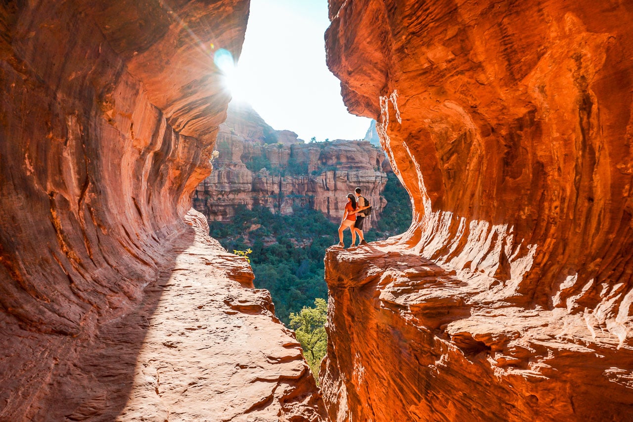
Cathedral Rock
1.2 miles Out-and-Back | 1 – 1.5 hours | Challenging
Red Rock Pass | Shuttle

Cathedral Rock is an iconic landmark and one of the best hikes in Sedona, especially at sunrise. It’s a natural sandstone butte with a saddle point (a flat ridge) between the two main spires of Cathedral Rock. This separation creates a breathtaking open-air natural atrium, almost resembling a cathedral (hence the name).
It is also a vortex with feminine energy, meaning you can feel a profound sense of emotions and spirituality. Many people like to hike Cathedral Rock as a healing journey and meditate at the top for self-reflection.
Cathedral Rock is a short yet challenging uphill hike with plenty of rock scrambling on an unshaded trail. Along the way, you will ascend steps and switchbacks while enjoying views of the Eastern mountains and rock formations. When you reach the top of the saddle, you are rewarded with panoramic views of the valley.
For a thrilling sensation and even better views, walk along the right side of the canyon wall and out onto the ledge (as pictured above). Of course, be careful, but it is not as scary as it looks.

Another fun experience at Cathedral Rock is on the far left side. Follow the trail along the left side of the canyon wall. Then, rock scramble up a narrow incline to reach the hidden pillar. This is known as the vortex site, which feels special because of its secluded atmosphere infused with sacred energy and unique views.

 Pro Tip
The Cathedral Rock parking lot has limited spaces (about 10 spots) and is closed from Thursday through Sunday between 8 a.m. and 5 p.m. During that timeframe, the trail is only accessible via the Sedona Shuttle service. This is why I prefer to hike the trail at sunrise. You can park at the trailhead any day of the week, and it offers incredible golden-hour views.
Devil’s Bridge
Varies between 2 to 5.7 miles Out-and-Back | 2 – 4 hours | Moderate
Red Rock Pass | Shuttle

Devil’s Bridge is undoubtedly one of Sedona’s most popular and best hikes, thanks to its Instagram-worthy fame. Despite its name, the views from the bridge are heavenly.
Overall, it’s a lovely and moderately easy hike on a flat trail in the floral desert. You will face a steep 400-foot climb near the end, but it’s quickly forgotten once you arrive at the iconic sandstone arch.
Soak in the views and conquer any nerves before cautiously walking across the top of the sandstone arch—the largest one in Sedona. Once you step foot on the arch, it’s relatively wide and not too daunting.
We left Devil’s Bridge around 7:30 a.m., and at least 20 people were waiting. Thankfully, everyone is usually patient and generous in helping take pictures.
Pro Tip
It’s highly recommended to arrive as early as possible for a sunrise hike to avoid the crowds and (almost) guarantee a parking spot. That said, it’s common you will always find people at the arch. So before you walk across, kindly ask someone to capture your Instagram-worthy picture or set up your tripod! As the day progresses, more hikers arrive, and yes, a long line will begin like people are waiting for a ride at Disneyland.
A few trailheads connect to Devil’s Bridge—Devil’s Bridge Trailhead, Dry Creek Trailhead, and Mescal Trailhead.
If you are lucky enough to have a 4WD vehicle with a high clearance, you can drive straight on the unpaved road to the Devil’s Bridge Trailhead for an easy 2-mile roundtrip hike.
If you do not have a 4WD vehicle, I recommend parking at the Mescal Trailhead. It’s a more scenic route that quickly connects to the Chuckwagon Trail. It’s a 3.9-mile roundtrip hike that takes 2 – 2.5 hours. This is the most popular route with limited parking spaces, so I recommend getting here as early as possible.
The other option is to park at Dry Creek Trailhead or take the Sedona Shuttle here. You can take two paths from Dry Creek Trailhead—via the Chuckwagon Trail or Dry Creek Road.
The Dry Creek Road is a dull, dusty dirt road jeeps use to get to the Devil’s Bridge Trailhead. Although it is not recommended, people still hike it because of the shorter 3.9-mile distance. The Chuckwagon Trail is more scenic, but it is 5.7 miles long.
Doe Mountain
1.5 miles Out-and-Back | 1 – 2 hours | Moderate
Red Rock Pass
Doe Mountain is one of the most fabulous sunrise hikes in Sedona, where you can watch several of Red Rock Country’s prominent landmarks wake up to the sun’s warm glow. To add the cherry on top of this wonderful hike at sunrise, you can watch hot air balloons soar across the painted sky.
If you find yourself sharing several hiking journeys with crowds of people, Doe Mountain will be a nice change. Despite being one of the best hikes in Sedona, it’s underrated, which results in having the trail almost entirely to yourself, making it a pleasant and tranquil experience.
Doe Mountain strikes a perfect balance between a slight challenge and a rewarding experience, making it a fun hike for anyone up for some adventure. While the trail is moderately difficult, it’s short and well-marked, with a gradual climb made easier by a series of switchbacks.
When you reach the flat-top mesa, you are welcomed with panoramic views that’ll take your breath away. You can see iconic Sedona landmarks like Bear Mountain, Wilson Mountain, Boynton Canyon, and Chimney Rock stretching out before you.
Fay Canyon
2.4 miles Out-and-Back | 1 – 1.5 hours | Easy
Red Rock Pass
Fay Canyon is the perfect hike in Sedona for anyone looking for a short, relaxing hike without breaking a sweat—especially on a hot day when the cool, shaded canyon offers a welcome break from the sun. It’s a great option for all ages and skill levels or a post-adventure cooldown after a longer hike.
The family-friendly trail is flat and sandy, winding through the canyon floor with minimal elevation gain. The towering red sandstone walls on either side keep you in awe as you wander through the canyon.
For those with extra energy, take a quick detour to the Fay Canyon Arch. It is a short spur trail that leads to a remarkable stone arch. It can be easy to miss the turnoff. So, I recommend downloading AllTrails offline maps.
The gentle hike eventually leads you to the canyon’s end, where you will see an “End of Trail” sign. You can turn around, or if you feel more adventurous (and a seasoned hiker), continue beyond the sign for another surprise. Trust me, you do not want to miss this—it is the best part of the Fay Canyon trail.
Follow the well-worn condition path, leading to some rock scrambling up to a vista. Continue along the ridge and enjoy spectacular views of the entire valley and beyond.
Merry Go Round Rock
Varies between 0.5 to 6.5 miles Out-and-Back | 20 minutes – 4 hours | Easy (Moderate to Cave)
Red Rock Pass

Merry Go Round is a sought-after hike off the beaten trail to capture an epic, Instagram-worthy picture of a uniquely shaped rock stack through a window of an unnamed cave. And it’s not just about the perfect shot for your feed—Merry Go Round Rock has one of the best viewpoints in Sedona!
Getting to Merry Go Round Rock requires a high-clearance vehicle or a 6.5-mile out-and-back hike via the Munds Wagon Trail. Although it’s a long hike with 1,100 feet of elevation gain, it’s a reasonably easy trail that meanders into the Munds Wildnerness but mostly runs parallel to the heavily traveled, dusty Schnebly Hill Road.
If you don’t have a high-clearance vehicle and aren’t up for the 6.5-mile hike, don’t worry—you’ve got options. You can rent a Jeep or go on a thrilling off-roading Jeep tour, which is what we did and highly recommend.
We had an absolute blast on our off-roading excursion with Arizona Safari Jeep Tours. If you also choose a Jeep tour, ask if you can take free time to venture to the unnamed cave. Merry Go Round Rock is a giant carousel-shaped sandstone formation, not the famed stacked rocks people seek out. Most tours will only hike to the vista for sweeping views.
If you drive to Merry Go Round Rock, the trail to the lower level starts by the bridge on the 4×4 road. The hike to the cave should take about 10 minutes, but it’s tricky to find if you are not actively looking for it.
Follow the trail and take a left to the ledge. The cave will be a few steps off the well-worn trail. Carefully scramble down rocks, and you should find it.
Secret Slick Rock
0.8 miles Out-and-Back | 20 minutes | Easy

Secret Slick Rock is an easy trail through desert shrubbery to a large slick rock mesa with prickly cactus and arguably the best views of Cathedral Rock. This short trail is a favorite for catching the sunset radiating Cathedral Rock or unwinding in the late afternoon after a long morning of hiking.
If you are lucky enough to hike the trail after rainfall, several water pockets will form pools, and you can see Cathedral Rock in the pool reflection.
Soldier Pass Cave
3.2 miles Out-and-Back | 2 – 3 hours | Moderate
Red Rock Pass | Shuttle

Soldier Pass Cave is one of the most popular hikes in Sedona for exploring a hidden cave. Along the way, you will pass unique sites such as Devil’s Kitchen and the Seven Sacred Pools.
Devil’s Kitchen is a large active sinkhole that collapsed in 1995. The Seven Sacred Pools are a series of small pools of water naturally carved out of red sandstone. Although they could dry up during warmer months, they are still cool to see.

We thoroughly enjoyed hiking Soldier Pass Cave, as the trail constantly takes you through different landscapes. One moment, you are trekking through the desert, and the next, you are strolling beneath the canopy of a lush evergreen forest or the red rock canyon floor.
Eventually, you will reach a junction. Take the right trail, and you will spot a cliffside wall with double arches stacked on each other. This is Soldier Pass Cave.
Climb the steps underneath the arch, and you will arrive inside Soldier Pass Cave. This uniquely shaped cave glows from sunlight peaking through the top. There is also a window cave (from the top arch) with stunning views and a great silhouette photo opportunity.
You can park at the trailhead or take the free Sedona Shuttle, which operates Thursday through Sunday between 8 a.m. and 5 p.m. The trailhead has gated parking with 14 spots, but it is only open Monday through Wednesday between 8 a.m. and 6 p.m.
If the parking lot is full or you prefer to hike Soldier Pass Cave outside this timeframe, you must park at Posse Grounds, about a mile away. From there, you can extend your hike by an additional two miles or take the Shuttle to the trailhead.
Subway Cave (via Boynton Canyon Trail)
6.1 miles Out-and-Back | 2.5 – 3.5 hours | Moderate
Red Rock Pass

The Subway Cave is easily one of the best hikes in Sedona. It is also my favorite of all the caves we explored in Sedona. The Subway Cave Trail is an easy, mostly flat trail with a moderately challenging, short rock scramble incline at the end.
The trail to the Subway Cave is at the 2-mile point on the Boynton Canyon Trail. You will start at the Boynton Canyon Trailhead and take a right around the 2-mile point.
Many articles or forums might tell you to look for a fallen Alligator Juniper tree, but it’s no longer there. The best way to find the right trail to the Subway Cave is to download the AllTrails offline map. We encountered at least a handful of hikers who got lost on the trail. We were able to help them find the right way—thanks, AllTrails!
The trail gradually ascends as you approach Subway Cave, where you’ll encounter a smooth sandstone incline. You are almost there! Scramble to the top, turn around, and prepare to be awestruck.
Take a moment to soak in the stunning surroundings at the back of the cave (as soon as you climb up). Then, walk along the left side to enjoy breathtaking canyon views.
To see the ruins, walk out onto the right side of the cave and continue around the bend. The trail continues along the canyon wall, where you will find petroglyphs until you reach the ruins. This is a sacred site, so please respect it and abide by the leave no trace principles.
The Subway Cave is one of Sedona’s top three most popular trails. The best time to hike is at sunrise to avoid the crowds and capture the stunning morning light as it illuminates the cave.
West Fork of Oak Creek Trail
6.5 miles Out-and-Back | 3 – 4 hours | Moderate
$12 Fee Upon Arrival

You have probably heard of The Narrows Trail at Zion National Park, but have you heard of “the narrows” in Sedona? The West Fork of Oak Creek Trail is 20 minutes outside the city but within the vast and beautiful Coconino National Forest.
The West Fork of Oak Creek Trail offers a refreshing change of pace from Sedona’s typical Red Rock Country hikes. This easy, flat trail takes you on an enchanting hike through a canyon, where towering rock walls and a lush forest create a serene atmosphere.
Along the way, you will cross 13 creek beds by balancing on log beams or stepping over smooth rocks. The adventure culminates at the trail’s end, where a knee-deep creek flows through a narrow slot canyon possibly more beautiful than Zion National Park.
You can turn back or wade through the chilly waters for a truly memorable and cool experience (pun intended!). With each bend of the creek, the views of this stunning slot canyon only get better, and you can choose how far to explore. The creek continues for another two miles, but this section is unmaintained, offering those adventurous a more thrilling hike.
Wilson Mountain
11.6 miles Out-and-Back | 6 – 7 hours | Hard
Red Rock Pass
Wilson Mountain is not for the faint-hearted but worth every step of effort. Whether you’re a seasoned hiker or an experienced adventurer, Wilson Mountain is one of the best hikes in Sedona.
It offers a challenging but rewarding experience with unforgettable vistas every step of the way. The panoramic views from the summit are some of the best you will ever see, making you feel like you are on top of the world!
As the highest peak in Sedona, the Wilson Mountain Trail climbs steadily through diverse terrain, ranging from red rock canyons to desert flora. The hike starts with a challenging ascent, gaining elevation quickly for the first few miles. Then, you get a short break from elevation before hiking steadily upwards once again until you reach a dense forest.
In the forest, you will encounter a junction with two distinct trails leading to breathtaking overlooks. The trail to the left takes you to the Sedona Overlook, while the one on the right leads to the North Canyon Overlook.
The Sedona Overlook is a popular favorite, but if you have the time and energy, try to visit both. It’s a bit of extra effort, but the stunning views from each are more than worth it! At the summit, you will be rewarded with sweeping 360-degree views of Sedona’s iconic landscape, including Oak Creek Canyon, Coffee Pot Rock, Capitol Butte, and the sprawling Verde Valley.
I hope you have enjoyed my guide to the best hikes in Sedona. Red Rock Country is truly a hiker’s paradise that you will surely revisit—it’s that amazing!


