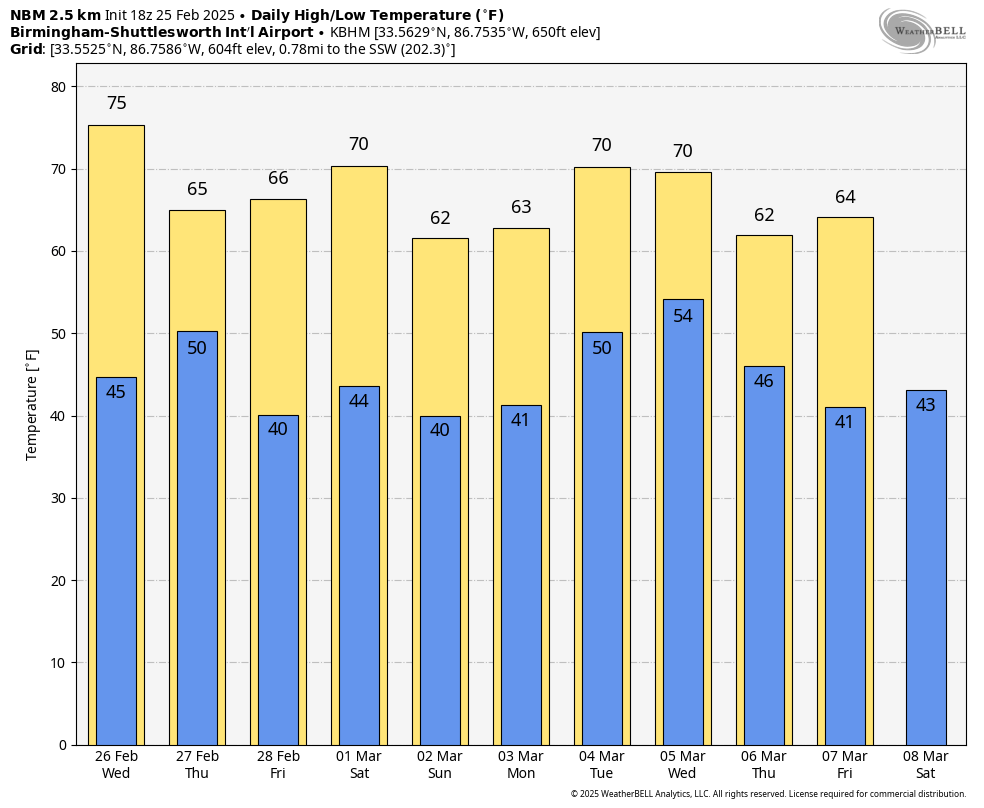
JUST LIKE SPRING: Temperatures have soared into the 70s statewide this afternoon with sunshine in full supply. Keep in mind the average high for Birmingham on February 25 is 62, and also keep in mind we had snow flurries flying around here last Thursday morning.
Tonight will be clear with a low in the 40s for most communities.
Tomorrow will be another mostly sunny, mild day with highs in the 70s.
A surface front will pass through the state on Thursday with clouds and a few spotty showers, but many places will see no rain at all. Then, we will enjoy delightful weather Friday through the weekend with sunny mild days and clear cool nights. Highs will be in the 60s and low 70s, lows mostly in the 40s. Colder spots will dip into the mid to upper 30s, but a widespread freeze is unlikely for Alabama for at least the next seven days.
NEXT WEEK: A fast moving disturbance could bring a few showers to the state Monday, but a more meaningful system will set the stage for rain and thunderstorms by Tuesday night or Wednesday. However, global models continue to show a huge spread this afternoon. The American global model (the GFS) shows a weak disturbance with just a few showers, but the reliable European is more aggressive with a dynamic system that could even bring some risk of severe storms to the Deep South. We will have much better clarity over the next few days… See the video briefing for maps, graphics, and more details.
ON THIS DATE IN 1934: An outbreak of six tornadoes killed nineteen in Mississippi, Alabama, and Georgia. The hardest-hit areas were Bowden, GA, and Shady Grove, AL. An estimated F4 tornado damaged or destroyed 90 homes, many in the Shady Grove community. One home in Lauderdale County, Mississippi, was picked up, thrown 400 feet, and blown to bits. Six family members were killed in the house. Three deaths occurred in two homes, and one preacher was killed during services.
ON THIS DATE TEN YEARS AGO: Alabamians experienced one of the largest snow storms on record on February 25, 2015 as over one foot of snow was unofficially measured along the Highway 278 corridor in Marion County. Snow totals of ranged from 1-2 inches near Interstate 20 to 8-12 inches further north to the Tennessee state line. The highest unofficial measurement came from Guin with 12.7 inches.
Look for the next video briefing here by 6:00 a.m. tomorrow…