
Have you ever thought about how the dirt beneath your feet became private property?
It might seem like an odd question. Today, land is a commodity – something bought, owned, and sold. So how did land change from just prairie, trees, and streams into real estate?

The Johnson County Museum’s newest special exhibit, Everyday Democracy: Life, Liberty, and the Pursuit of Happiness in Johnson County, explores how people here have wrestled with the nation’s founding ideals over time. It’s a story of everyday choices – sometimes collaborative, sometimes in conflict.
Running through it all is land: owning it, buying it, farming it, developing it, preserving it.
Here’s how Johnson County’s landscape became property.
Before Individual Ownership
For the Indigenous tribes who lived here, land was not something to own.
As the ancestral territory of the Osage and the Kanza (Kaw) Tribes, this region was used, cared for, and shared. Land was held communally – for the benefit of the whole community – and understood as a resource to steward, not a commodity to divide.
That began to change in 1825, when a treaty signed in St. Louis forced the Osage and the Kaw from their ancestral lands. The federal government removed them – and other tribes – to reservations elsewhere in what is now Kansas.
The reservations marked a major shift. For the first time, the region’s rolling hills and winding rivers were divided into defined, rectangular pieces of property.


These maps are from the Everyday Democracy exhibit and are used as overlays there to show the changing Indigenous landscape. In “Indigenous Homelands,” we see a landscape of fluid boundaries for the regions’ Native American tribes. In “Early Removals and Reservations,” those tribes have been removed to federal reservations, rectangles superimposed on the same landscape. Johnson County Museum
One of those rectangular reservations covered what is now Johnson County and was assigned to the Shawnee, who had been removed from the Ohio River Valley to a reservation in Kansas. Within the Shawnee Tribe, there were differing views about the land. Some members maintained traditional communal practices and land stewardship (traditionalists). Others adopted Euro-American ideas of individual land ownership and ways of living (assimilationists).
In 1854, when Congress created the Kansas Territory, the Shawnee were forced to choose between removing to a smaller reservation in a smaller Indian Territory (Oklahoma) to continue traditional ways of life or remaining in Johnson County as individual landowners. The federal government gave those who stayed here 200-acre land grants.
At the same time, Euro-Americans began arriving in the region, eager to purchase land.
But before land could be sold, it had to be transformed.
Turning a Landscape into a Grid
To sell land, it first had to be measured.
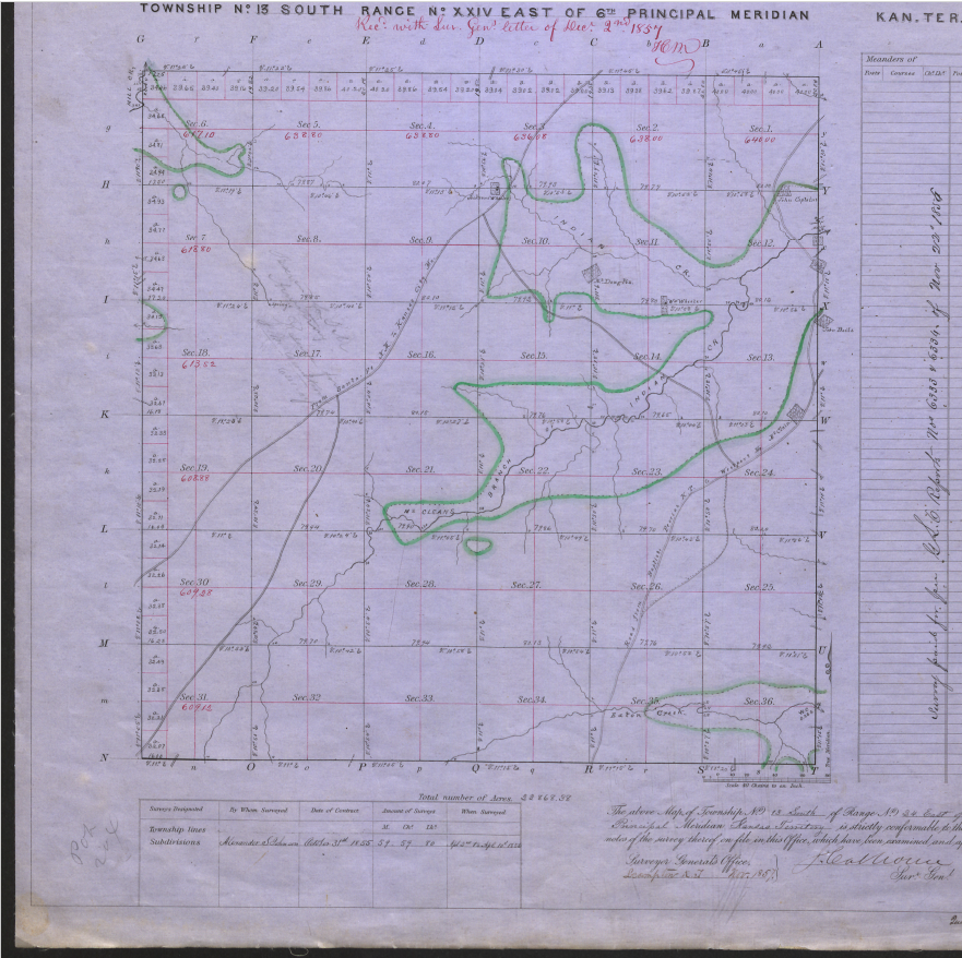
Surveying – an ancient practice – became the tool that reshaped Kansas. Surveyors imposed a standardized system on the landscape, dividing it into a grid that could be bought and sold.
In the United States, that grid system is known as “S – T – R”:
- T – Townships: 6-by-6-mile squares counted north/south of baselines placed across the country.
- R – Range: number of townships counted east or west of meridians lines placed across the country.
- S – Sections: 1-by-1-mile squares within townships, each totaling 640 acres.
The section became the basic building block of property.

From there, land could be subdivided further – halves, quarters, or smaller – each precisely described and recorded. Zooming out, a township was comprised of 36 sections. Each parcel within it had a precise legal name.
For example, the S – T – R written NE ½ SE ¼ 7 – 12 S – 25 E identifies the northeast half of the southeast quarter of the 7th section of land in the 12thtownship south of the baseline, in the 25thrange east of the 6th principal meridian; or, the parcel located roughly at 7401 Johnson Dr. – Shawnee Mission North High School today.
Surveying Johnson County
In 1855, the federal government ordered a general survey of the Kansas Territory.

Survey crews spread out across the region, measuring land with chains and marking boundaries using items like “a limestone 16-in thick” or natural markers such as “a black walnut 14-in in diameter.” They kept detailed journals, noting the quality of the land, whether it was rocky, fertile, hilly, wooded, watered, or barren.
Between 1856 and 1857, surveyors crossed Johnson County’s landscape to record the section grid across its lands. It was painstaking work, completed on foot, moving across the rolling prairies and wooded creeks.
Their work turned a lived-in landscape into something else entirely: a series of precisely-measured, standardized parcels ready for sale.

Purchasing Property
Once surveyed, the land was officially on the market.
Settlers could purchase a piece of property anywhere in its boundaries and record that purchase at the courthouse (after the county was established in 1855). This meant the land that makes up Johnson County became a commodity, something that could be bought, owned, and sold, with inherent value based on human perceptions and preferences.
From the late 1850s onward, people arrived in Johnson County and bought land in different ways. Some farmers acquired large tracts – hundreds or even thousands of acres. Others owned much smaller plots.
Over time, as towns formed and grew into cities, the meaning of property continued to evolve.

Subdividing Land, Selling Lots
Large parcels of farmland didn’t easily translate into neighborhoods.
To solve that, developers created plat maps – detailed plans that divided parcels of land into smaller individual pieces (called lots), along with streets and shared spaces like parks or schools.
In Olathe, for example, Stevenson’s 2nd Addition in 1868 transformed a single piece of about 100 acres of land into 20 residential lots connected to the city street grid. Filing a plat map made those lots official – and sellable.

Suburban developers used the same approach on a larger scale. Figures like J.C. Nichols (Prairie Village, Mission Hills, Fairway, among others), the Kroh Brothers (Leawood), or William Strang (Overland Park), set out rules for the land they platted. These were called declarations of restrictions and required future purchasers to follow those rules. In this way, a developer could maintain control and, they hoped, maintain the value of investment in real estate. Property law advanced to support these new land uses. Restrictions could contain things like racially restrictive covenants, which limited buyers based on skin color or ethnicity (through 1954), as well as the creation of HOAs (homeowner associations) that provide a legal mechanism to challenge rule-breakers in court.
Developers still use plat maps and declarations of restrictions to sell lots in their communities today.
Learning about this Land
Transforming land into property took time, labor, and policy – and it fundamentally changed how people understood the landscape.
That system is still with us.
The land you live on today has a story. Its boundaries, ownership, and use are all part of a long historical process. You can trace that story through property records, plat maps, and deed abstracts – many of which are still accessible through Johnson County.
These formal documents are stored with the county but can be viewed a few different ways – at the Record and Tax Administration (RTA) office in Olathe, by accessing the county’s myAIMS mapping system online, or by ordering a property abstract from a real estate company.
To explore these ideas further, visit “Everyday Democracy” at the Johnson County Museum. The exhibit invites you to consider how land, policy, and people have shaped this place – and what that means for the future.
The exhibit is included in regular admission and is open Monday through Saturday, 9am to 4:30pm. You can plan your visit at JCPRD.com/Museum!